IMAGES TAKEN NEAR TO
BN2 0DD
Introduction
This page details the photographs taken nearby to BN2 0DD by members of the Geograph project.
The Geograph project started in 2005 with the aim of publishing, organising and preserving representative images for every square kilometre of Great Britain, Ireland and the Isle of Man.

There are currently over 7.5m images from over14,400 individuals and you can help contribute to the project by visiting https://www.geograph.org.uk
Image Map
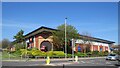
Images are licensed for reuse under creativecommons.org/licenses/by-sa/2.0
Notes
- Clicking on the map will re-center to the selected point.
- The higher the marker number, the further away the image location is from the centre of the postcode.
Image Listing (360 Images Found)
Images are licensed for reuse under creativecommons.org/licenses/by-sa/2.0
Image
Details
Distance
1
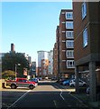
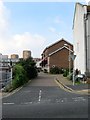
Site of Sloane Street, Brighton
The course of the service road for Leach Court, Sloan Court and Patching Lodge follows what would have been the northern row of terraced housing on Sloan Street which was developed in the 1820s and demolished and removed from the map in the late 1960s. The street contained two pubs; The Rifleman, closed in 1911, and the Cadogan Arms that closed in 1943. See http://regencysociety-jamesgray.com/volume22/source/jg_22_123.html for a view in 1961. Behind the tree on the left is the Brighton Telephone Exchange.
Image: © Simon Carey
Taken: 1 Nov 2015
0.01 miles
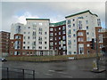
2
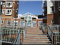
Entrance to Patching Lodge
The recent development has 78 retirement flats http://www.hanover.org.uk/housing/sales/patching-lodge-brighton , see Image] for wider view
Image: © Paul Gillett
Taken: 12 Feb 2011
0.03 miles
3
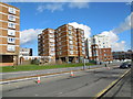
Patching Lodge and Leach Court
Residential homes in Eastern Road
Image: © Paul Gillett
Taken: 13 Feb 2014
0.03 miles
4
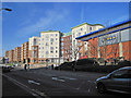
Patching Lodge on Junction of Freshfield Road and Edward Street
Image: © Julian P Guffogg
Taken: 13 Jan 2012
0.04 miles
5
Southdown Mews, Brighton
A cul de sac off Freshfield Road that was built on the site of a former Southdown bus depot that existed here from 1915 until its closure in 1991.
Image: © Simon Carey
Taken: 4 Oct 2015
0.04 miles
6
Patching Lodge
Viewed from the junction of Eastern Road and Freshfield Road, the recent development has 78 retirement flats http://www.hanover.org.uk/housing/sales/patching-lodge-brighton
Image: © Paul Gillett
Taken: 28 Nov 2009
0.04 miles
7
Kemp Town, Gala Bingo Hall
On Eastern Road; a stone dates the building to 1997. https://www.galabingoclubs.co.uk/club/brighton.html
Image: © Mike Faherty
Taken: 22 Sep 2018
0.04 miles
8
The Graperies, Brighton
A cul de sac off Park Street built on the site of the former Southdown Coach Depot which operated from here from 1915 until its closure in the 1990s. The name derives from a market garden to the north known as The Graperies and now part of Image
Image: © Simon Carey
Taken: 1 Nov 2015
0.05 miles
9
Buzz Bingo, Brighton
Look carefully, this is a train at the corner of the building. A bit of 'Googling' suggested (possibly tongue in cheek) that in bingo lingo ‘5 & 9’ is the Brighton line. 5+9 was the Brighton line because of some railway company back in the day using a promotional campaign about how it takes less than an hour (59minutes) to get to London from Brighton.
A more plausible explanation is that the train is a tribute to the fact that the bingo club was built on what used to be the former Kemptown railway station.
Image: © Richard Rogerson
Taken: 29 Apr 2023
0.06 miles
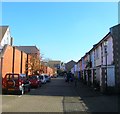
10
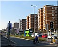
Leach Court, Eastern Road, Brighton
Sheltered housing on the northern side of Eastern Road built around 1973 on the site of Sloane Street. Eastern Road is a dual carriageway up to the junction with Upper Bedford Street and Freshfield Road part of a 1960s plan to provide a highway to head east out of Brighton. Edward Street was dualled in the 1960s and this section begun so after which resulted in the complete demolition of the northern side and the road running parallel to the north, Sloane Street. See http://regencysociety-jamesgray.com/volume22/source/jg_22_108.html for a similar view taken in 1966. However, financial issues in the 1970s meant the end of the scheme which in all likelihood would have run into huge problems obtaining land around Brighton College and the Royal Sussex County Hospital.
Image: © Simon Carey
Taken: 11 Oct 2015
0.06 miles