IMAGES TAKEN NEAR TO
Cranborne Avenue, EASTBOURNE, BN20 7TT
Introduction
This page details the photographs taken nearby to Cranborne Avenue, BN20 7TT by members of the Geograph project.
The Geograph project started in 2005 with the aim of publishing, organising and preserving representative images for every square kilometre of Great Britain, Ireland and the Isle of Man.

There are currently over 7.5m images from over14,400 individuals and you can help contribute to the project by visiting https://www.geograph.org.uk
Image Map
Images are licensed for reuse under creativecommons.org/licenses/by-sa/2.0
Notes
- Clicking on the map will re-center to the selected point.
- The higher the marker number, the further away the image location is from the centre of the postcode.
Image Listing (67 Images Found)
Images are licensed for reuse under creativecommons.org/licenses/by-sa/2.0
Image
Details
Distance
1
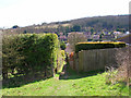
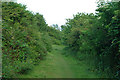
Footpath to Cranbourne Avenue
Linking Warren Hill with this westernmost outpost of Eastbourne. Looking south.
Image: © Simon Carey
Taken: 5 Apr 2006
0.04 miles
2
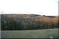
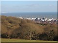
View over The Warren
A housing estate on the edge of Eastbourne.
Image: © N Chadwick
Taken: 12 Apr 2010
0.05 miles
3
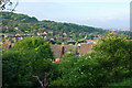
Eastbourne residential area
These houses are built in a big bay in the high ground of the downs to the west of the old town.
Image: © Robin Webster
Taken: 11 Jun 2010
0.11 miles
4
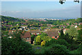
View over Eastbourne
The South Downs National Park boundary runs round the back fences of the houses in the coombe below.
Image: © Robin Webster
Taken: 11 Jun 2010
0.11 miles
5
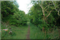
Path through woods above Eastbourne
This roughly follow the 100 m contour, i.e. about 50 m down from the top of the downs.
Image: © Robin Webster
Taken: 11 Jun 2010
0.13 miles
6

Path through woods above Eastbourne
The white flowers on the right are on Guelder Rose, which likes somewhat damp areas. The steep slopes of the downs often have areas of slight out seepage, one such must be along here.
Image: © Robin Webster
Taken: 11 Jun 2010
0.14 miles
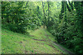
7
Path through woods above Eastbourne
This roughly follow the 100 m contour, i.e. about 50 m down from the top of the downs.
Image: © Robin Webster
Taken: 11 Jun 2010
0.15 miles
9
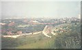
View over Eastbourne in 1967
It would seem that the development of land for residential buildings was just starting on that below The Downs.
Image: © John Baker
Taken: Unknown
0.17 miles
10
Path through woods above Eastbourne
This roughly follow the 100 m contour, i.e. about 50 m down from the top of the downs.
Image: © Robin Webster
Taken: 11 Jun 2010
0.17 miles