IMAGES TAKEN NEAR TO
Michel Dene Road, EASTBOURNE, BN20 0JY
Introduction
This page details the photographs taken nearby to Michel Dene Road, BN20 0JY by members of the Geograph project.
The Geograph project started in 2005 with the aim of publishing, organising and preserving representative images for every square kilometre of Great Britain, Ireland and the Isle of Man.

There are currently over 7.5m images from over14,400 individuals and you can help contribute to the project by visiting https://www.geograph.org.uk
Image Map
Images are licensed for reuse under creativecommons.org/licenses/by-sa/2.0
Notes
- Clicking on the map will re-center to the selected point.
- The higher the marker number, the further away the image location is from the centre of the postcode.
Image Listing (42 Images Found)
Images are licensed for reuse under creativecommons.org/licenses/by-sa/2.0
Image
Details
Distance
1
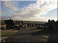
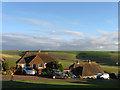
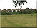
Michel Dene Road, East Dean
A view from the junction with The Link. This is the middle section of the road that snakes its way from Summer Down to the A259 below and was developed during the 1960s. The view also takes in the sea in the distance and the old Belle Tout lighthouse towards the centre of the image on the far horizon.
Image: © Simon Carey
Taken: 23 Nov 2013
0.03 miles
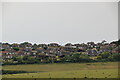
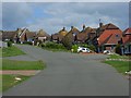
3
The Link, East Dean
The eastern edge of the modern housing estate enviably located next to open downland.
Image: © Andrew Smith
Taken: 23 Aug 2008
0.04 miles
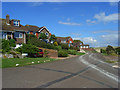
4
Michel Dene Road, East Dean, East Sussex
The sea can be seen on the horizon and in the centre of the view the lighthouse at Belle Tout can just be seen.
Image: © Kevin Gordon
Taken: 24 Jun 2008
0.06 miles
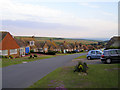
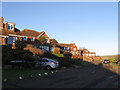
5
Summerdown Lane, East Dean
The road runs from The Link down to Michel Dene Road and is the eastern end of the Downlands estate that covers much of East Dean and Friston north of the A259 and east of the Jevington Road. Those bungalows on the eastern side of the road have a rather splendid view across to Eastdean Down.
Image: © Simon Carey
Taken: 23 Nov 2013
0.06 miles
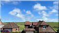
6
Michel Dene Road, East Dean
Part of the modern estate that makes up the greater part of the village.
Image: © Andrew Smith
Taken: 23 Aug 2008
0.06 miles
7
Houses on Summerdown Lane - and view ESE
The avenues hereabouts had an odd look about them, and I couldn't quite put my finger on why that was. Then it occurred to me that none of them had pavements. I suppose the original idea was to prevent this area from looking like an "estate" - but it's a little impractical for pedestrians. (Admittedly there isn't much traffic up here - or many people on foot for that matter.)
Image: © Ian Hawfinch
Taken: 12 May 2022
0.06 miles
8
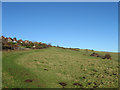
Permissive Bridleway, Summer Down
Linking the east-west bridleway next to Summerdown Farm with another bridleway that heads through the Downlands Estate of East Dean, saving horse riders the need to ride through the residential streets.
Image: © Simon Carey
Taken: 26 Dec 2013
0.06 miles
9
Edge of the Downland Estate
A permissive path leads north from a five-way junction, running close to houses on The Link.
Image: © David M Clark
Taken: 18 Jul 2023
0.07 miles
10
The Link, East Dean
A residential road off Michel Dene Road that ends in a dead end after the junction with Summerdown Lane. This part of East Dean, built on the southern slopes of Summer Down, was not completed until the 1970s.
Image: © Simon Carey
Taken: 26 Dec 2013
0.10 miles