IMAGES TAKEN NEAR TO
Old London Road, BRIGHTON, BN1 8YA
Introduction
This page details the photographs taken nearby to Old London Road, BN1 8YA by members of the Geograph project.
The Geograph project started in 2005 with the aim of publishing, organising and preserving representative images for every square kilometre of Great Britain, Ireland and the Isle of Man.

There are currently over 7.5m images from over14,400 individuals and you can help contribute to the project by visiting https://www.geograph.org.uk
Image Map
Images are licensed for reuse under creativecommons.org/licenses/by-sa/2.0
Notes
- Clicking on the map will re-center to the selected point.
- The higher the marker number, the further away the image location is from the centre of the postcode.
Image Listing (114 Images Found)
Images are licensed for reuse under creativecommons.org/licenses/by-sa/2.0
Image
Details
Distance
2
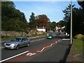
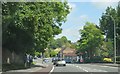
Patcham: Old London Road (1)
Houses faced with both knapped and unknapped flints can be found in the centre of the old part of Patcham village, here lining the Old London Road. The narrowness of the road here, coupled with the amount of tourist traffic to Brighton, made a bypass essential from the very early days of motoring, and the current A23 London Road that bypasses this part of Patcham to the west was built in 1926, being shown on the 1930 edition of the Ordnance Survey map.
Image: © Nigel Cox
Taken: 8 Jun 2008
0.06 miles
3
Patcham: Old London Road (2)
The 1899 Ordnance Survey map shows a smithy on the site of Patcham Garage, while the mosaic with the black writing on a white background on the larger brick building reads 'Brighton Equitable Co-operative Society Limited'.
Image: © Nigel Cox
Taken: 8 Jun 2008
0.06 miles
4
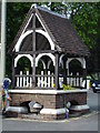
Horse trough, London Road, Patcham
This old horse trough is nowadays planted with annual flowers. In addition, it serves as a bus stop.
Image: © Brian Slater
Taken: 21 Apr 2009
0.06 miles
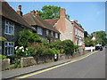
6
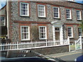
House in Old London Road, Patcham
The Old London Road was part of the main London Road until the Patcham by-pass opened in 1926. It retains many listed buildings dating mainly to the 18th century.
http://www.mybrightonandhove.org.uk/category_id__714_path__0p114p450p.aspx
Image: © Paul Gillett
Taken: 22 May 2009
0.07 miles
7
Flint cottages in Church Hill, Patcham (2)
Image: © Brian Slater
Taken: 21 Apr 2009
0.07 miles
8
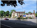
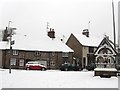
Black Lion, Patcham
Hotel and pub on the A23, a noted landmark as one enters Brighton on the London Road
Image: © Paul Gillett
Taken: 29 Jun 2013
0.07 miles
9
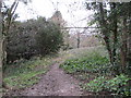
Woodland Path to Patcham-By-Pass
Public footpath FPB 86 in Coney Wood.
Image: © Peter Holmes
Taken: 18 Jan 2014
0.08 miles
10
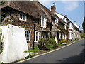
4-4a Church Hill, Patcham
Flint built cottages at the bottom of Church Hill next to the junction with London Road. The buildings date from the 18th century. To the right is Patcham Fountain erected in 1887 to mark Queen Victoria's golden jubilee on the site of a former donkey wheel that operated the village well. The road was once known as Spring Street as it ran next to the Wellesborne, Brighton's lost river, and this part of Patcham can still be prone to flooding today, the last occurrence being during the heavy rains of December 2012.
Image: © Simon Carey
Taken: 20 Jan 2013
0.08 miles