IMAGES TAKEN NEAR TO
Reynolds Lane, ARUNDEL, BN18 0QX
Introduction
This page details the photographs taken nearby to Reynolds Lane, BN18 0QX by members of the Geograph project.
The Geograph project started in 2005 with the aim of publishing, organising and preserving representative images for every square kilometre of Great Britain, Ireland and the Isle of Man.

There are currently over 7.5m images from over14,400 individuals and you can help contribute to the project by visiting https://www.geograph.org.uk
Image Map
Images are licensed for reuse under creativecommons.org/licenses/by-sa/2.0
Notes
- Clicking on the map will re-center to the selected point.
- The higher the marker number, the further away the image location is from the centre of the postcode.
Image Listing (36 Images Found)
Images are licensed for reuse under creativecommons.org/licenses/by-sa/2.0
Image
Details
Distance
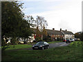
1

House in Slindon
Writing in Pevsner's The Buildings of England: Sussex, Ian Nairn describes Slindon "A good flint and brick village on the south slopes of the Downs. .. Quite unspoilt."
It doubtless helps that the National Trust owns the Slindon Estate and two thirds of the properties still belong to the estate. This is the house behind the cricket bat memorial seen at http://www.geograph.org.uk/photo/4041241
Image: © Marathon
Taken: 21 Jun 2014
0.03 miles
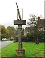
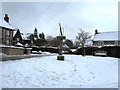
2

Cricket memorial at Slindon
The inscription on the column of this Millennium memorial where Reynolds Lane meets School Hill and Park Lane says: "THIS SIGN WAS DONATED BY THE SLINDON PUDDING CLUB AND DEPICTS THE SHAPE & SIZE OF THE BAT AND WICKET THAT WAS FIRST USED IN SLINDON IN 1731."
Image: © Marathon
Taken: 21 Jun 2014
0.03 miles
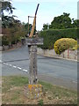
3
Slindon Cricket Sign
The sign depicts the size and shape of the bat and wicket first used in Slindon in 1731. It was donated by the Slindon Pudding Club in 2000.
Image: © Peter Whitcomb
Taken: 30 Oct 2011
0.03 miles
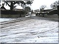
4
Junction of Park and Reynolds Lanes with bridleway in Slindon
The millennium commemoration is on the grass verge. See also http://www.geograph.org.uk/photo/1662760.
Image: © Shazz
Taken: 21 Mar 2012
0.03 miles
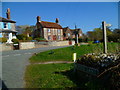
5
Reynolds Lane
Looking towards the junction with Park Lane and School Hill. Mead Cottages are to the right with Hope Cottage in the distance at the junction.
Image: © Simon Carey
Taken: 30 Oct 2010
0.03 miles
6
Cricket Memorial Slindon
This Cricket Memorial stands on the crossroads of Park Lane and Reynolds Road.This was presented to the village in 2000 by the Pudding Club.
Image: © Roger Pagram
Taken: 4 Oct 2009
0.04 miles
7
Meadsway
A small cul-de-sac off Reynolds Lane built as a council estate in the 1940s.
Image: © Simon Carey
Taken: 30 Oct 2010
0.04 miles
8
Millennium sign for Slindon
Widely recognised as the birthplace of cricket as their sign depicts. The Slindon cricket club have been playing for 250 years
Image: © Dave Spicer
Taken: 10 Jan 2010
0.04 miles
9
Millstone by wall at the junction of Park Lane and school Hill
Image: © Dave Spicer
Taken: 10 Jan 2010
0.06 miles
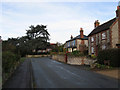
10
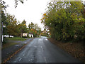
Reynolds Lane
Connecting Slindon with the A29 - though the lane is much older, being an ancient route southwards to Slindon Common, then on to Walberton Common and eventually Walberton itself. The white building in the distance is Slindon Forge which only closed in 2008. It is currently going through the planning process to turn it into a community shop, café and information centre.
Image: © Simon Carey
Taken: 30 Oct 2010
0.07 miles