IMAGES TAKEN NEAR TO
Copse Lane, ARUNDEL, BN18 0QH
Introduction
This page details the photographs taken nearby to Copse Lane, BN18 0QH by members of the Geograph project.
The Geograph project started in 2005 with the aim of publishing, organising and preserving representative images for every square kilometre of Great Britain, Ireland and the Isle of Man.

There are currently over 7.5m images from over14,400 individuals and you can help contribute to the project by visiting https://www.geograph.org.uk
Image Map
Images are licensed for reuse under creativecommons.org/licenses/by-sa/2.0
Notes
- Clicking on the map will re-center to the selected point.
- The higher the marker number, the further away the image location is from the centre of the postcode.
Image Listing (18 Images Found)
Images are licensed for reuse under creativecommons.org/licenses/by-sa/2.0
Image
Details
Distance
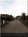
1
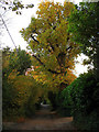
Copse Lane
A private road though public bridleway that once linked West Walberton Lane to Arundel, the A27. The dualling of the latter means the lane is now a dead end. The elm is in full autumnal colour.
Image: © Simon Carey
Taken: 30 Oct 2010
0.06 miles
2
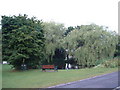
Walberton Duck Pond
West of the village centre.
Image: © Chris Shaw
Taken: Unknown
0.07 miles
3
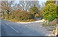
Start of Copse Lane bridleway 392
Very old track from West Walberton to what was once Walberton Common and then on to Slindon village.
Image: © David Garraway
Taken: 2 Jan 2009
0.11 miles
4
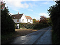
Hancombe, West Walberton Lane
One of a large number of houses that have been built along the lane from Fontwell to Walberton many of which sprung up between the wars.
Image: © Simon Carey
Taken: 30 Oct 2010
0.12 miles
5
Long Mead
A cul-de-sac off West Walberton Lane built in the 1960s on the site of a nursery.
Image: © Simon Carey
Taken: 30 Oct 2010
0.13 miles
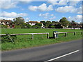
6
Brook Barn Piece
The name of the field according to the 1846 tithe map viewed from West Walberton Lane. Hazel Plantation is the wood at the end of the field.
Image: © Simon Carey
Taken: 30 Oct 2010
0.15 miles
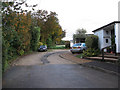
7
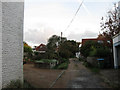
Mill Lane
A narrow lane that once led to Short's windmill that operated beyond the barn to the right from the 1820s to closure and demolition in 1896.
Image: © Simon Carey
Taken: 30 Oct 2010
0.17 miles
8
Footpath across the green at Walberton Green
Image: © Dave Spicer
Taken: 29 Sep 2012
0.18 miles
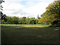
9
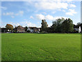
Walberton Green
Opposite view of Image with the pond amongst the trees to the right.
Image: © Simon Carey
Taken: 30 Oct 2010
0.18 miles
10
Field Close
A small cul-de-sac off The Street built in the 1960s.
Image: © Simon Carey
Taken: 30 Oct 2010
0.19 miles