IMAGES TAKEN NEAR TO
Goodhew Close, ARUNDEL, BN18 0JA
Introduction
This page details the photographs taken nearby to Goodhew Close, BN18 0JA by members of the Geograph project.
The Geograph project started in 2005 with the aim of publishing, organising and preserving representative images for every square kilometre of Great Britain, Ireland and the Isle of Man.

There are currently over 7.5m images from over14,400 individuals and you can help contribute to the project by visiting https://www.geograph.org.uk
Image Map
Images are licensed for reuse under creativecommons.org/licenses/by-sa/2.0
Notes
- Clicking on the map will re-center to the selected point.
- The higher the marker number, the further away the image location is from the centre of the postcode.
Image Listing (35 Images Found)
Images are licensed for reuse under creativecommons.org/licenses/by-sa/2.0
Image
Details
Distance
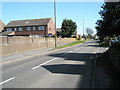
1
Looking from Burndell Road into Goodhew Close
Image: © Basher Eyre
Taken: 8 Apr 2009
0.04 miles
2
The old canal bridge, north of Burndell Road, Yapton
The old bridge (pictured) is scheduled to be demolished by the developers, when the new estate of some 170 houses is built in and around these fields where the bridge is situated. Quite when the building will commence nobody knows but planning permission has been granted so building with almost certainly take place. Unless the bridge is listed by the local authority, we shall lose it. The canal was originally constructed to carry (amongst other things) munitions to and from London/Portsmouth during the Napoleonic wars. It was never a viably operating system.
Image: © Peter H Jones
Taken: 23 May 2012
0.07 miles
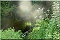
3

Burndell Bridge
One of four brick arch bridges built in Yapton over the Portsmouth and Arundel Canal, which opened in 1823 and was abandoned in 1855. This bridge was built to allow the owner of Burndell Farm to access their land on the opposite bank of the canal. The farm has now been developed into a small estate, but to this day the bridge is still awaiting restoration.
Image: © Jim Butler
Taken: 9 Jul 2021
0.08 miles
4
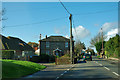
House at the parish boundary
Once the first house in Yapton, this flint and brick house is set at an odd angle to the road for no obvious reason.
Image: © Robin Webster
Taken: 26 Jan 2012
0.08 miles
6
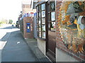
Unusual postbox in Burndell Road
It is in fact just for private mail for the tool shop.
Image: © Basher Eyre
Taken: 8 Apr 2009
0.09 miles
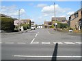
7
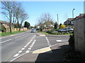
Junction of Burndell Road and Fellows Gardens
Image: © Basher Eyre
Taken: 8 Apr 2009
0.10 miles
8
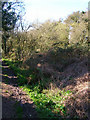
Site of Former Portsmouth-Arundel Canal
The footpath on the left follows the old towpath whilst the former canal bed is now overgrown with foliage. This part opened in 1821 but was obsolete by 1848 after the opening of the nearby railway.
Image: © Simon Carey
Taken: 21 Mar 2008
0.11 miles
9
Looking from Burndell Road into Downview Road
Image: © Basher Eyre
Taken: 8 Apr 2009
0.11 miles