IMAGES TAKEN NEAR TO
Binsted Lane, ARUNDEL, BN18 0AL
Introduction
This page details the photographs taken nearby to Binsted Lane, BN18 0AL by members of the Geograph project.
The Geograph project started in 2005 with the aim of publishing, organising and preserving representative images for every square kilometre of Great Britain, Ireland and the Isle of Man.

There are currently over 7.5m images from over14,400 individuals and you can help contribute to the project by visiting https://www.geograph.org.uk
Image Map
Images are licensed for reuse under creativecommons.org/licenses/by-sa/2.0
Notes
- Clicking on the map will re-center to the selected point.
- The higher the marker number, the further away the image location is from the centre of the postcode.
Image Listing (17 Images Found)
Images are licensed for reuse under creativecommons.org/licenses/by-sa/2.0
Image
Details
Distance
1
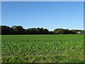
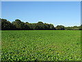
Old Furze Field
The name of the field according to the 1838 tithe map. Viewed from Old Scotland Lane with Foxes Cottages to the right and the hedgerow at the far end of the field marking the course of Binsted Lane. Furze in a field name is usually an indicator of land hacked out of woodland.
Image: © Simon Carey
Taken: 10 Oct 2010
0.12 miles
2
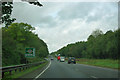
Approaching the A27
On Binsted Lane, beside Brickkiln Copse, heading northwards to the A27.
Image: © Chris Thomas-Atkin
Taken: 14 Jan 2019
0.13 miles
4
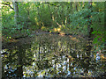
Pond, Lower Kiln Copse
Just off Old Scotland Lane near the western edge of the wood.
Image: © Simon Carey
Taken: 10 Oct 2010
0.16 miles
5
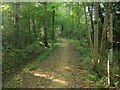
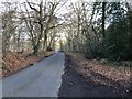
Old Scotland Lane
A bridleway that links both ends of Binsted Lane. The route is very old with some evidence to suggest that this was the original Roman road to Chichester. It was certainly being used as a highway by the 13th century and was still in use in 1840 when it was called Scotland Lane. Since the 20th century it has been reduced to a bridleway and seems to have been resurfaced in the last few years, I came down here in 2005 on my bike in the middle of summer and got bogged down in the mud. Pedler's Croft is to the left whilst Lower Kiln Copse is on the right, both defined by extensive woodbanks which is usually a sign of an ancient route.
Image: © Simon Carey
Taken: 10 Oct 2010
0.17 miles
6
Selwyn Hole Field
The name of the field according to the 1838 tithe map. Barn's Copse is the wood on the left.
Image: © Simon Carey
Taken: 10 Oct 2010
0.17 miles
7
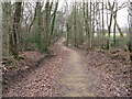
Repaired bridleway
The track is named Old Scotland Lane and the woods are called 'Scotland'.
In 2020 a protest group are campaigning against the use of these ancient woods to be part of the new Arundel bypass.
Image: © Dave Spicer
Taken: 31 Jan 2009
0.18 miles
8
Lower Kiln Copse
The name of the wood according to the 1838 tithe map which now seems to be part of the area known as Scotland.
Image: © Simon Carey
Taken: 10 Oct 2010
0.19 miles
9
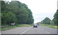
A27 - approaching the turning for Binstead, banned for most
Very few ordinary folk could legally take this turning, this sign indicates only unpowered vehicles can use it. The actual lane entrance has signs relenting a little and allowing all vehicles for access only. Curiously the other end of the lane appears to be open to all, so it is a sort of semi-one-way road.
Image: © Robin Webster
Taken: 23 Sep 2011
0.20 miles
10
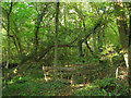
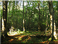
Pedler's Croft
A traditional fence has been erected to protect something. The wood lies to the south of Old Scotland Lane.
Image: © Simon Carey
Taken: 10 Oct 2010
0.23 miles