IMAGES TAKEN NEAR TO
Climping, LITTLEHAMPTON, BN17 5RD
Introduction
This page details the photographs taken nearby to BN17 5RD by members of the Geograph project.
The Geograph project started in 2005 with the aim of publishing, organising and preserving representative images for every square kilometre of Great Britain, Ireland and the Isle of Man.

There are currently over 7.5m images from over14,400 individuals and you can help contribute to the project by visiting https://www.geograph.org.uk
Image Map
Images are licensed for reuse under creativecommons.org/licenses/by-sa/2.0
Notes
- Clicking on the map will re-center to the selected point.
- The higher the marker number, the further away the image location is from the centre of the postcode.
Image Listing (31 Images Found)
Images are licensed for reuse under creativecommons.org/licenses/by-sa/2.0
Image
Details
Distance
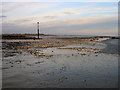
1
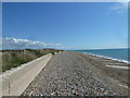
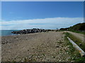
Along the coast from Atherington to Elmer (16)
Image: © Basher Eyre
Taken: 15 Aug 2011
0.03 miles
2
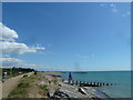
Poole Place, Elmer Beach
The coast between Elmer and Littlehampton is the only non-urbanised area between Chichester Harbour and Brighton, where beaches lead straight on to open fields.
Image: © Simon Carey
Taken: 2 Jul 2006
0.05 miles
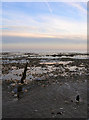
3
Along the coast from Atherington to Elmer (18)
Image: © Basher Eyre
Taken: 15 Aug 2011
0.05 miles
4
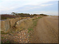
World War Two Beach Defences near Elmer
The boundary to the beach is marked by a flint wall and big concrete blocks, beyond the stunted tree line to the left are farmlands.
Image: © Simon Carey
Taken: 22 Dec 2007
0.06 miles
5
Along the coast from Atherington to Elmer (17)
Image: © Basher Eyre
Taken: 15 Aug 2011
0.08 miles
6
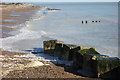
World War 2. Defences
These large concrete blocks had, for many years stood at the top of a bank, backed by bushes. The storms of January 2018 washed away the bank and bushes and have left the blocks in the sea. The original shore line is indicated by the far groyne which used to end at the top of the beach. LinkImage
Image: © Peter Jeffery
Taken: 17 Feb 2018
0.08 miles
7
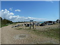
Along the coast from Atherington to Elmer (20)
Image: © Basher Eyre
Taken: 15 Aug 2011
0.09 miles
8
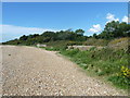
Along the coast from Atherington to Elmer (15)
Image: © Basher Eyre
Taken: 15 Aug 2011
0.09 miles
9
Rocks, Elmer Beach
Strewn around at the edge of a sea defence.
Image: © Simon Carey
Taken: 22 Dec 2007
0.10 miles
10
Remains of a Groyne, Elmer Beach
Taken from the end of the current rock sea defence looking out to sea following the line of a former wooden groyne and the rocks that are only visible at low tide.
Image: © Simon Carey
Taken: 22 Dec 2007
0.13 miles