IMAGES TAKEN NEAR TO
Surrenden Road, BRIGHTON, BN1 6WQ
Introduction
This page details the photographs taken nearby to Surrenden Road, BN1 6WQ by members of the Geograph project.
The Geograph project started in 2005 with the aim of publishing, organising and preserving representative images for every square kilometre of Great Britain, Ireland and the Isle of Man.

There are currently over 7.5m images from over14,400 individuals and you can help contribute to the project by visiting https://www.geograph.org.uk
Image Map
Images are licensed for reuse under creativecommons.org/licenses/by-sa/2.0
Notes
- Clicking on the map will re-center to the selected point.
- The higher the marker number, the further away the image location is from the centre of the postcode.
Image Listing (18 Images Found)
Images are licensed for reuse under creativecommons.org/licenses/by-sa/2.0
Image
Details
Distance
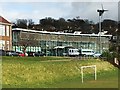
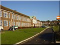
2
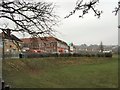
Varndean College
The original building on the left opened as a boys girl in 1932 to complement the neighbouring girls school, now Varndean Secondary School, opened the previous year. This remained the state of affairs until 1972 when girls were admitted but lasted only for three years when a reorganisation of schools turned this into a sixth form college and the old girls school into a mixed comprehensive. Three other schools, Dorothy Stringer High School, Balfour Juniors and Balfour Infans, are also nearby, a legacy of the old municipal education committee purchasing the land from Varndean Farm in 1909. The college also has its own wind turbine next to the modern extension which is just visible through the blanket of snow that appeared overnight.
Image: © Simon Carey
Taken: 18 Dec 2009
0.05 miles
3
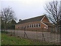
Varndean College Grounds
The playing fields at Varndean College.
Image: © Chris Thomas-Atkin
Taken: 5 Dec 2017
0.06 miles
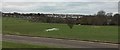
4
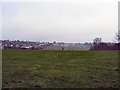
Varndean Sixth Form College
Viewed from Surrenden Road looking over the snow covered rear of the school grounds. On a clear day the view from here can extend down to the Brighton Wheel on the seafront, though on this day the constant light snow reduced visibility quite drastically. The school was built in 1932 and was originally a grammar school for boys until girls began to be admitted in 1972. In 1975 the whole school system in Brighton was overhauled and the buildings became the current sixth form college.
Image: © Simon Carey
Taken: 20 Jan 2013
0.06 miles
5
Varndean College
website: http://www.varndean.ac.uk/
The college was founded in 1884 in York Place, Brighton as a boys' Secondary School and moved to its current site in 1932, later attaining grammar school status, becoming Varndean Grammar School for Boys, administered by the Education Committee for the County Borough of Brighton. In 1972 the first girls were admitted to the school, and in 1975 it became a sixth form college http://en.wikipedia.org/wiki/Varndean_College
Image: © Paul Gillett
Taken: 20 Feb 2011
0.07 miles
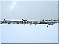
6
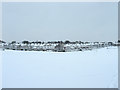
Playing Fields, Varndean College
The goalposts are just about visible next to the blanket of snow that appeared overnight. Much of the land here once belonged to Varndean Farm and was purchased by the old borough education committee. The area now hosts five schools; Balfour Infants, Balfour Juniors, Dorothy Stringer High School, Varndean Secondary School and Varndean College. The latter two were originally built in the 1930s and were a separate boys and girls school until a reorganisation of education facilities in 1975. The houses beyond the fields belong to Friar Road and Friar Crescent.
Image: © Simon Carey
Taken: 18 Dec 2009
0.08 miles
7
Varndean College
website: http://www.varndean.ac.uk/
The college was founded in 1884 in York Place, Brighton as a boys' Secondary School and moved to its current site in 1932, later attaining grammar school status, becoming Varndean Grammar School for Boys, administered by the Education Committee for the County Borough of Brighton. In 1972 the first girls were admitted to the school, and in 1975 it became a sixth form college http://en.wikipedia.org/wiki/Varndean_College
Image: © Paul Gillett
Taken: 20 Feb 2011
0.08 miles
8
Varndean College fields
website: http://www.varndean.ac.uk/
The college was founded in 1884 in York Place, Brighton as a boys' Secondary School and moved to its current site in 1932, later attaining grammar school status, becoming Varndean Grammar School for Boys, administered by the Education Committee for the County Borough of Brighton. In 1972 the first girls were admitted to the school, and in 1975 it became a sixth form college http://en.wikipedia.org/wiki/Varndean_College
Image: © Paul Gillett
Taken: 20 Feb 2011
0.10 miles
9
Varndean College
http://www.varndean.ac.uk
Image: © Brian Dungate
Taken: 8 Dec 2005
0.10 miles
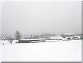
10
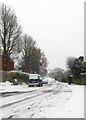
Friar Road, Hollingbury
Residential road linking Surrenden Road to Ditchling Road.
Image: © Simon Carey
Taken: 20 Jan 2013
0.11 miles