IMAGES TAKEN NEAR TO
Baker Way, LITTLEHAMPTON, BN16 4PR
Introduction
This page details the photographs taken nearby to Baker Way, BN16 4PR by members of the Geograph project.
The Geograph project started in 2005 with the aim of publishing, organising and preserving representative images for every square kilometre of Great Britain, Ireland and the Isle of Man.

There are currently over 7.5m images from over14,400 individuals and you can help contribute to the project by visiting https://www.geograph.org.uk
Image Map
Images are licensed for reuse under creativecommons.org/licenses/by-sa/2.0
Notes
- Clicking on the map will re-center to the selected point.
- The higher the marker number, the further away the image location is from the centre of the postcode.
Image Listing (10 Images Found)
Images are licensed for reuse under creativecommons.org/licenses/by-sa/2.0
Image
Details
Distance
2
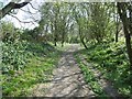
Angmering, byway
Running parallel to A280, from Angmering High Street to A259.
Image: © Mike Faherty
Taken: 13 Apr 2019
0.19 miles
3
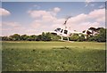
Helicopter at Worthing Rugby Club
Coming in to land
Image: © Josie Campbell
Taken: Unknown
0.20 miles
5
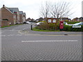
Pillar box on corner of Foxwood Avenue and Rowan Way
Image: © Shazz
Taken: 3 Dec 2015
0.21 miles
6
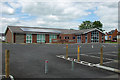
Angmering Community entre
Very recently completed, yet the C has dropped off the name - or perhaps it was never fixed on?
Image: © Robin Webster
Taken: 20 Jun 2010
0.22 miles
7
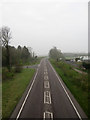
Angmering By-Pass
The by-pass, the A280, was opened in 2003 to relieve the heavily congested narrow roads of Angmering village centre. Taken from the footbridge opened at the same time with Manor Nurseries to the right and the junction with Ecclesden Lane to the left.
Image: © Simon Carey
Taken: 13 Apr 2009
0.23 miles
8
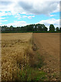
Field, Roundstone Farm
The farm has one big field which it splits into strips growing different produce, here a section of wheat ends before a recently ploughed area. Taken from the footpath that runs through the field from Ecclesden Lane to the A259 and looking towards a hedge that marks the course of the A280.
Image: © Simon Carey
Taken: 20 Jul 2008
0.23 miles
9
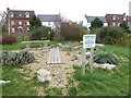
Southern Water Legacy Garden
For further information see https://www.southernwater.co.uk/south-south-east-in-bloom_NEW.
Image: © Shazz
Taken: 3 Dec 2015
0.24 miles
10
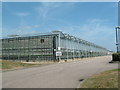
Greenhouse effect
Mega glasshouses in the centre of the square.
Image: © Chris Shaw
Taken: Unknown
0.25 miles