IMAGES TAKEN NEAR TO
The Square, LITTLEHAMPTON, BN16 4EQ
Introduction
This page details the photographs taken nearby to The Square, BN16 4EQ by members of the Geograph project.
The Geograph project started in 2005 with the aim of publishing, organising and preserving representative images for every square kilometre of Great Britain, Ireland and the Isle of Man.

There are currently over 7.5m images from over14,400 individuals and you can help contribute to the project by visiting https://www.geograph.org.uk
Image Map
Images are licensed for reuse under creativecommons.org/licenses/by-sa/2.0
Notes
- Clicking on the map will re-center to the selected point.
- The higher the marker number, the further away the image location is from the centre of the postcode.
Image Listing (61 Images Found)
Images are licensed for reuse under creativecommons.org/licenses/by-sa/2.0
Image
Details
Distance
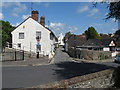
1
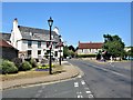
Water Lane, Angmering
Angmering is a large village between Littlehampton and Worthing just to the south of the A27 and about 1½ miles north of the English Channel. This view is at the junction of Arundel Road (left) and High Street (right).
Image: © G Laird
Taken: 16 Jul 2019
0.01 miles
2
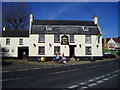
The Lamb Inn, Angmering
A Grade II Listed building, dating back to the 18th century. In the 19th century a room by the archway to the stables was used as the village mortuary. www.angmeringvillage.co.uk/history/Lamb.htm
Image: © Peter Holmes
Taken: 12 Nov 2007
0.02 miles
3
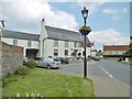
Angmering, Lamb
Former coaching inn on The Square. Two rooms downstairs: left, dining, right, drinking, with central counter, old village photos on walls, large open fireplace and some old wooden beams; accommodation. Cask ales on offer: Fuller's London Pride, Greyhound Amber Eyes & Old Village. The building is C18, and Grade II listed by Historic England: https://historicengland.org.uk/listing/the-list/list-entry/1027684
Image: © Mike Faherty
Taken: 13 Apr 2019
0.02 miles
4
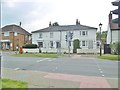
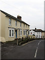
Angmering, cottages
Hazel Cottage and Byfleet House, on The Square; early C19, Grade II listed by Historic England: https://historicengland.org.uk/listing/the-list/list-entry/1027685
Image: © Mike Faherty
Taken: 13 Apr 2019
0.02 miles
5
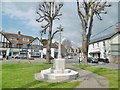
Angmering War Memorial
On The Square; resplendent, probably after recent restoration. The memorial is Grade II listed by Historic England: https://historicengland.org.uk/listing/the-list/list-entry/1360799
Image: © Mike Faherty
Taken: 13 Apr 2019
0.03 miles
6
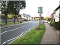
Angmering: Village sign
The sign commemorated the first 100 years of Angmering Parish Council in 1994.
Image: © Nigel Cox
Taken: 17 Sep 2009
0.03 miles
7
High Street
Heading down to the village centre around The Square.
Image: © Simon Carey
Taken: 13 Apr 2009
0.03 miles
10
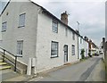
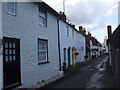
Angmering, Church Road
A narrow road from The Square to St. Margaret's, lined with C18 flint-faced cottages. Nos 1-5 are C18, and Grade II listed by Historic England: https://historicengland.org.uk/listing/the-list/list-entry/1027715
Image: © Mike Faherty
Taken: 13 Apr 2019
0.04 miles