IMAGES TAKEN NEAR TO
Stafford Road, BRIGHTON, BN1 5PF
Introduction
This page details the photographs taken nearby to Stafford Road, BN1 5PF by members of the Geograph project.
The Geograph project started in 2005 with the aim of publishing, organising and preserving representative images for every square kilometre of Great Britain, Ireland and the Isle of Man.

There are currently over 7.5m images from over14,400 individuals and you can help contribute to the project by visiting https://www.geograph.org.uk
Image Map
Images are licensed for reuse under creativecommons.org/licenses/by-sa/2.0
Notes
- Clicking on the map will re-center to the selected point.
- The higher the marker number, the further away the image location is from the centre of the postcode.
Image Listing (178 Images Found)
Images are licensed for reuse under creativecommons.org/licenses/by-sa/2.0
Image
Details
Distance
1
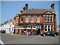
Brighton: The Chimney House gastropub
This was formerly the Marquess of Exeter in Exeter Street, and the coats of arms in the pediments reflect this. The refurbishment work evidently in progress in Simon's Image has now been completed. The Chimney House's website is here http://www.chimneyhouse.co.uk/index.php
Image: © Nigel Cox
Taken: 8 Jun 2008
0.01 miles
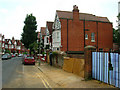
2
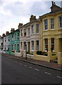
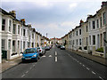
Stafford Road
The road connects Port Hall Road to Buxton Road and was constructed slightly later than the rest of the area around the early 1890s as lower middle class housing as opposed to the other streets laid out at the same time which tended to be red brick upper middle class.
Image: © Simon Carey
Taken: 29 Aug 2007
0.02 miles
3
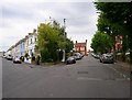
Exeter Street
Taken from Upper Hamilton Road with Buxton Road to the left. The terraces of Exeter Street were developed in the early 1880s as a lower middle class suburb.
Image: © Simon Carey
Taken: 29 Aug 2007
0.03 miles
4
The Chimney House, Exeter Street
The only pub in the actual Port Hall suburb in a triangular junction caused by the meeting of Exeter Street (left), Upper Hamilton Road (Right) and Buxton Road (Behind the photographer).
Image: © Simon Carey
Taken: 29 Aug 2007
0.04 miles
5
Stafford Road
Linking Port Hall Road with Buxton Road and developed in the early 1890s.
Image: © Simon Carey
Taken: 2 Feb 2009
0.04 miles
6
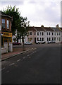
Buxton Road
At the junction of Stafford Road which veers off to the left. Both roads were constructed in the early 1890s but Buxton Road is red brick upper middle class whilst Stafford Road is terraced lower middle.
Image: © Simon Carey
Taken: 29 Aug 2007
0.06 miles
7

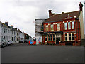
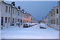
Brighton: Stafford Road
Please see Simon's Image for the history of the road. The dark green house in his image is visible on the left side of this one.
Image: © Nigel Cox
Taken: 8 Jun 2008
0.06 miles
8
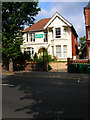
Coventry Street
Looking south towards the street's junction with Upper Hamilton Road. Developed in the early 1880s as a lower middle class suburb.
Image: © Simon Carey
Taken: 29 Aug 2007
0.07 miles
9
Al Quds Mosque, Dyke Road
Opposite the sixth form college. This converted house has been a mosque for over 30 years and was an stop off point in the early 1980s for the notorious Abu Hamza when he was studying at a local university and working as a nightclub bouncer.
Image: © Simon Carey
Taken: 29 Aug 2007
0.07 miles
10
Chatsworth Road
The last area to be developed between the railway and Dyke Road and it shows in the architecture. Completed in 1899 this middle class road had moved away from the red brick of Buxton Road towards the early 'Tudorbethan' style that became popular during Edwardian times particularly in Hove. Unfortunately, like Hove, some of these houses have disappeared to be replaced by blocks of ordinary flats, some of which are in the process of being developed on the right hand side. The road connects Old Shoreham Road with Port Hall Road.
Image: © Simon Carey
Taken: 29 Aug 2007
0.07 miles