IMAGES TAKEN NEAR TO
Kingscote Way, BRIGHTON, BN1 4GJ
Introduction
This page details the photographs taken nearby to Kingscote Way, BN1 4GJ by members of the Geograph project.
The Geograph project started in 2005 with the aim of publishing, organising and preserving representative images for every square kilometre of Great Britain, Ireland and the Isle of Man.

There are currently over 7.5m images from over14,400 individuals and you can help contribute to the project by visiting https://www.geograph.org.uk
Image Map
Images are licensed for reuse under creativecommons.org/licenses/by-sa/2.0
Notes
- Clicking on the map will re-center to the selected point.
- The higher the marker number, the further away the image location is from the centre of the postcode.
Image Listing (985 Images Found)
Images are licensed for reuse under creativecommons.org/licenses/by-sa/2.0
Image
Details
Distance
1
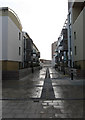
Walkway, New England Quarter
Linked to this Image and separating Block C into two parts.
Image: © Simon Carey
Taken: 11 Jan 2009
0.01 miles
2
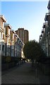
Kingscote Way, Brighton
Part of the Brighton Station development that was completed around 2006. The pedestrianised walk runs between Sinclair Walk and Cheapside with this section roughly following the course of Queen Street which was built in the late 1840s and demolished around 1900 in order to extend the goods yard. The area then became part of the coal yard until that was shut in the 1970s and subsequently remained undeveloped until 2004. Theobald House is the high rise beyond.
Image: © Simon Carey
Taken: 21 Nov 2015
0.02 miles
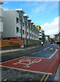
3

New Buildings near Brighton Station
See also Image
Image: © Julian P Guffogg
Taken: 10 May 2011
0.03 miles

5
New England Street
The eastern extent of the new New England Quarter development. Until the 1960s this road was actually Fleet Street with New England Street being limited to the northern section between New England Road and York Hill. When the area was redeveloped in the 1960s and the old railway workers houses demolished and replaced with faceless concrete blocks and car parks the whole stretch was renamed New England Street replacing New York Street and Fleet Street the former middle and southern sections respectively. However, the latter has been reprieved and given to the new section to the west which loops around the development. Consequently, the former busy New England Street has seen itself broken into two distinct parts and this section into a quiet back street.
Image: © Simon Carey
Taken: 1 Oct 2006
0.03 miles
6
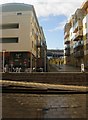
Fenchurch Way
Pedestrian walkway connecting New England Street with Fleet Street within the New England Quarter, a recent development constructed on the site of the former locomotive works and goods yard. As it climbs the steps it crosses Kingscote Way another walkway which runs north-south. This area also has some commercial activity with a Sainsbury's out of shot to the right, a Japanese grocery store and Subway to the left out of shot and the Paris cafe bar in view. Brighton station can just be seen beyond the end of the walkway.
Image: © Simon Carey
Taken: 25 Nov 2009
0.03 miles
7
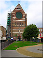
St Bartolomews Church
Extraordinary church built between 1872-74. The houses either side may give an indication to the size and scale of the building where the nave is 135 feet high which as a far higher than Westminster Cathedral. The church was said to have been built to the exact dimensions of Noah's Ark and until the 1960s was a landmark for this area of Brighton. Unfortunately, the erection of large concrete office blocks and car parks have somewhat reduced the impact and scale on the surrounding area.
Image: © Simon Carey
Taken: 30 Sep 2006
0.03 miles
8
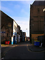
Providence Place
Small back street running parallel with the main London Road. To the right is the rear of St Bartholomews church and to the left a small garage and Harlequins Bar, a place to drink if you are a man and like your beer whilst wearing a nice floral dress.
Image: © Simon Carey
Taken: 5 Nov 2006
0.03 miles
9
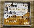
Wall plaque on Sainsbury's
One of a set of three graphic representations connected with Brighton. Situated on the southern wall of the supermarket.
Image: © Peter Whitcomb
Taken: Unknown
0.03 miles
10
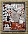
Wall plaque at Sainsbury's
One of a set of three wall plaques on the southern wall of the supermarket. Each shows graphic representations connected with Brighton.
Image: © Peter Whitcomb
Taken: Unknown
0.03 miles