IMAGES TAKEN NEAR TO
New England Street, BRIGHTON, BN1 4GH
Introduction
This page details the photographs taken nearby to New England Street, BN1 4GH by members of the Geograph project.
The Geograph project started in 2005 with the aim of publishing, organising and preserving representative images for every square kilometre of Great Britain, Ireland and the Isle of Man.

There are currently over 7.5m images from over14,400 individuals and you can help contribute to the project by visiting https://www.geograph.org.uk
Image Map
Images are licensed for reuse under creativecommons.org/licenses/by-sa/2.0
Notes
- Clicking on the map will re-center to the selected point.
- The higher the marker number, the further away the image location is from the centre of the postcode.
Image Listing (552 Images Found)
Images are licensed for reuse under creativecommons.org/licenses/by-sa/2.0
Image
Details
Distance
1
Car Park, Providence Place
Viewed from New England Street with part of New England House to the right. Providence Place runs along the rear of shops that front onto London Road. All of this area was once covered with small terraced houses built for the workers of the adjacent Brighton locomotive works which closed in 1958. The houses were all cleared in the early 1960s. In the distance is Round Hill the name of both the hill and the suburb that occupies it.
Image: © Simon Carey
Taken: 12 Mar 2013
0.02 miles
2
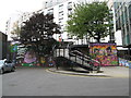
Steps in York Hill leading to New England Street
Image: © Josie Campbell
Taken: 6 Aug 2011
0.03 miles
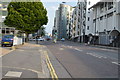
4
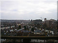
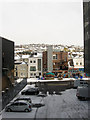
View of Brighton from the viaduct
Taken from the impressive viaduct that carries the railway towards Lewes and Eastbourne, part of which can be seen in the left hand of this picture Image This view looks south east capturing most of the grid square that ends beyond the huge structure of St Bartholomews church. The line of houses to the right are the backs of shops and houses along the A23 northbound only Preston Road. Those to the left the A23southbound only Beaconsfield Road. These join at Preston Circus to the right of the yellow building which is this, Image The modern office buildings on the right were erected in the 1960s when the opld houses built for rail workers were pulled down. The cranes behind are currently developing the site of the old goods yard. The imposing St Bartholomews Church was opened in 1874 and was built to the dimensions of Noah's Ark. It has the tallest roof of any parish church in England. To the left the trees mark out Image The hilly nature of Brighton can be made out in the background with the old workers' terraces now a home for many of the city's students.
Image: © Simon Carey
Taken: 4 Feb 2006
0.03 miles
5
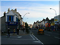
London Road
From the junction with Rose Hill Terrace with a few more veteran cars going past.
Image: © Simon Carey
Taken: 5 Nov 2006
0.03 miles
7
New and Not So Old, New England Quarter
Looking through the recently developed New England Quarter towards New England Street and part of New England House built in the 1960s after a large scale slum clearance between Trafalgar Street and New England Road.
Image: © Simon Carey
Taken: 31 Jul 2011
0.03 miles
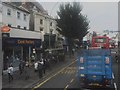
9
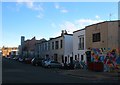
Elder Place, Brighton
A former narrow residential street that runs from York Hill to New England Road that was developed in the 1820s. The western side was demolished in its entirety in the early 1960s leaving just the eastern side which is now largely the rear of premises on London Road.
Image: © Simon Carey
Taken: 21 Nov 2015
0.03 miles