View of Brighton from the viaduct
Introduction
The photograph on this page of View of Brighton from the viaduct by Simon Carey as part of the Geograph project.
The Geograph project started in 2005 with the aim of publishing, organising and preserving representative images for every square kilometre of Great Britain, Ireland and the Isle of Man.

There are currently over 7.5m images from over 14,400 individuals and you can help contribute to the project by visiting https://www.geograph.org.uk
View of Brighton from the viaduct
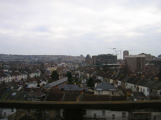
Image: © Simon Carey Taken: 4 Feb 2006
Taken from the impressive viaduct that carries the railway towards Lewes and Eastbourne, part of which can be seen in the left hand of this picture Image This view looks south east capturing most of the grid square that ends beyond the huge structure of St Bartholomews church. The line of houses to the right are the backs of shops and houses along the A23 northbound only Preston Road. Those to the left the A23southbound only Beaconsfield Road. These join at Preston Circus to the right of the yellow building which is this, Image The modern office buildings on the right were erected in the 1960s when the opld houses built for rail workers were pulled down. The cranes behind are currently developing the site of the old goods yard. The imposing St Bartholomews Church was opened in 1874 and was built to the dimensions of Noah's Ark. It has the tallest roof of any parish church in England. To the left the trees mark out Image The hilly nature of Brighton can be made out in the background with the old workers' terraces now a home for many of the city's students.
Images are licensed for reuse under creativecommons.org/licenses/by-sa/2.0
Image Location
Latitude
50.832373
Longitude
-0.138306