IMAGES TAKEN NEAR TO
Findon By Pass, WORTHING, BN14 0TL
Introduction
This page details the photographs taken nearby to Findon By Pass, BN14 0TL by members of the Geograph project.
The Geograph project started in 2005 with the aim of publishing, organising and preserving representative images for every square kilometre of Great Britain, Ireland and the Isle of Man.

There are currently over 7.5m images from over14,400 individuals and you can help contribute to the project by visiting https://www.geograph.org.uk
Image Map
Images are licensed for reuse under creativecommons.org/licenses/by-sa/2.0
Notes
- Clicking on the map will re-center to the selected point.
- The higher the marker number, the further away the image location is from the centre of the postcode.
Image Listing (57 Images Found)
Images are licensed for reuse under creativecommons.org/licenses/by-sa/2.0
Image
Details
Distance
1
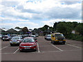
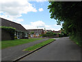
Wyevale Garden Centre
The Findon branch of the garden centre lies on the site of former nurseries to the south of the bypass.
Image: © Simon Carey
Taken: 2 Jun 2013
0.03 miles
2
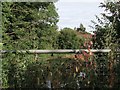
Black Horse Pond
Just about visible beyond the nettles and the metal fence. The current pond was made in 1938 after the construction of the bypass buried the old one underneath the new highway. Its original location was at the junction of High Street and Rogers Lane and was named after the nearby pub.
Image: © Simon Carey
Taken: 26 Jul 2013
0.04 miles
3
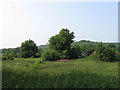
The Three Acres
The name of the field according to Findon's 1839 tithe map. For a number of years it was used as allotment gardens but is now overgrown and used for nothing. Viewed from the Findon Bypass with West Hill in the background.
Image: © Simon Carey
Taken: 13 Jul 2013
0.06 miles
4
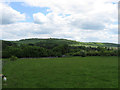
The Seven Acres
The name of the field according to Findon's 1839 tithe map viewed from Roger's Lane with Cissbury Ring prominent in the background.
Image: © Simon Carey
Taken: 2 Jun 2013
0.08 miles
5
The Chase
A small estate built in the mid 1980s on the site of a field once known as the Malt Compiers according to Findon's 1839 tithe map.
Image: © Simon Carey
Taken: 13 Jul 2013
0.10 miles
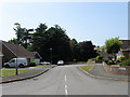
6
Findon By-Pass
Built in 1938 to take motor traffic away from the village's narrow lanes. This section actually uses the course of the old High Street and looks towards the junction s with Cross lane and Nepcote.
Image: © Simon Carey
Taken: 2 Jun 2013
0.10 miles
7
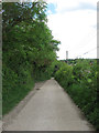
Roger's Lane
A private track linking Roger's Farm with the A24. It is also a public footpath.
Image: © Simon Carey
Taken: 2 Jun 2013
0.10 miles
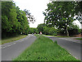
8
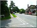
View north west on Findon High Street
The camera is at the dead end of Findon High Street beside the A24 dual carriageway.
Image: © Shazz
Taken: 23 Jun 2012
0.11 miles
9
Cross Lane
This narrow lane heads into the centre of the village from the A24. To the left is the junction with The Chase.
Image: © Simon Carey
Taken: 2 Jun 2013
0.12 miles
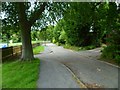
10
View south from Findon High Street towards the A24
Image: © Shazz
Taken: 23 Jun 2012
0.13 miles