IMAGES TAKEN NEAR TO
Long Furlong, WORTHING, BN13 3UW
Introduction
This page details the photographs taken nearby to Long Furlong, BN13 3UW by members of the Geograph project.
The Geograph project started in 2005 with the aim of publishing, organising and preserving representative images for every square kilometre of Great Britain, Ireland and the Isle of Man.

There are currently over 7.5m images from over14,400 individuals and you can help contribute to the project by visiting https://www.geograph.org.uk
Image Map
Images are licensed for reuse under creativecommons.org/licenses/by-sa/2.0
Notes
- Clicking on the map will re-center to the selected point.
- The higher the marker number, the further away the image location is from the centre of the postcode.
Image Listing (38 Images Found)
Images are licensed for reuse under creativecommons.org/licenses/by-sa/2.0
Image
Details
Distance
1
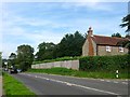
Plantation Cottage, Clapham Common, Patching
Located on the junction of Longfurlong and Clapham Cottage and at a point where the parish boundary deviates to the east of the former following the boundary of the cottage. The building dates back to the early 19th century.
Image: © Simon Carey
Taken: 28 Aug 2017
0.01 miles
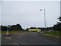
2
The A280 north through Clapham to the A24
Image: © Dave Spicer
Taken: 20 Dec 2009
0.03 miles
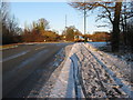
3
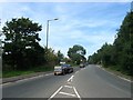
Longfurlong
The A280 as it heads northwards from the Patching Interchange. The highway was for many centuries a route north to the Downs until it was turnpiked in 1823 and rerouted via Findon. The road itself forms the parish boundary between Clapham to the east and Patching to the west.
Image: © Simon Carey
Taken: 28 Aug 2017
0.06 miles
4
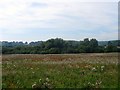
East Field
The name of the field according to Patching's 1847 tithe map that is located to the west of Longfurlong and north east of Patching Pond. To the north is Image
Image: © Simon Carey
Taken: 28 Aug 2017
0.09 miles
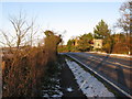
6
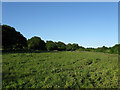
Reclaimed Field, Clapham Common
Once the A27 but returned to pasture once the nearby dual carriageway and flyover junction were built in the early 1990s.
Image: © Simon Carey
Taken: 30 May 2009
0.14 miles
8
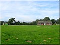
Clapham and Patching Village Hall
Built in the 1970s and designed to serve both neighbouring villages. The green space was originally an open field called Frogs Hole Field that was later merged with Image to the south before being turned into a cricket ground after the Second World War. Clapham and Patching CC merged with Littlehampton and now play in the town though the old strip still remains with the moles now colonising the outfield. To the north is Image
Image: © Simon Carey
Taken: 28 Aug 2017
0.15 miles