IMAGES TAKEN NEAR TO
Ferring Lane, WORTHING, BN12 6QU
Introduction
This page details the photographs taken nearby to Ferring Lane, BN12 6QU by members of the Geograph project.
The Geograph project started in 2005 with the aim of publishing, organising and preserving representative images for every square kilometre of Great Britain, Ireland and the Isle of Man.

There are currently over 7.5m images from over14,400 individuals and you can help contribute to the project by visiting https://www.geograph.org.uk
Image Map
Images are licensed for reuse under creativecommons.org/licenses/by-sa/2.0
Notes
- Clicking on the map will re-center to the selected point.
- The higher the marker number, the further away the image location is from the centre of the postcode.
Image Listing (70 Images Found)
Images are licensed for reuse under creativecommons.org/licenses/by-sa/2.0
Image
Details
Distance
1
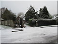
Snow on Ferring Lane
Public footpath 2122 to Littlehampton Road (A259) at junction with Downview Avenue starts here.
Image: © Peter Holmes
Taken: 31 Jan 2015
0.06 miles
2
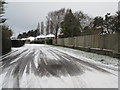
Snow on Downview Avenue
Public footpath 2123 to Langbury Lane, one of Ferring's many private roads.
Image: © Peter Holmes
Taken: 31 Jan 2015
0.06 miles
3

St Mary's Gardens, Ferring
A cul de sac off Langbury Lane built as an infill development around 2007. Once a field called Pledges Croft according to Ferring's 1837 tithe map.
Image: © Simon Carey
Taken: 6 Aug 2017
0.06 miles
4
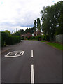
Downview Avenue
Residential road in the northern part of Ferring village taken from the junction with Ferring Lane.
Image: © Simon Carey
Taken: 20 Jul 2008
0.07 miles
5
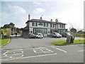
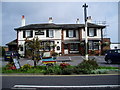
Ferring, Henty Arms
Public house on Ferring Lane, dating from 1830, and faced with brick and pebbles. Internally, traditional two-room layout, with lounge left (eating and drinking) and public bar right (drinking); back central counter, pool, billiards, darts, TV, garden, and five cask ales on offer.
Image: © Mike Faherty
Taken: 9 Mar 2019
0.08 miles
6
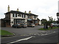
The Henty Arms, Ferring
The Henty Arms at 2 Ferring Lane, previously known as the New Inn, was built for
Edwin Henty in the late 1830’s, to replace a nearby older ale house.
Image: © Peter Holmes
Taken: 15 Oct 2007
0.08 miles
7
The Henty Arms
Just by the railway in Ferring Street
Image: © Josie Campbell
Taken: 26 Jul 2011
0.08 miles
8
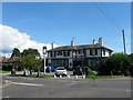
Henty Arms, Ferring Lane, Ferring
Built in 1830 on the junction of Ferring Lane and Langbury Lane, the two routes into the old village centre, and thus predating the railway by at least a decade. Originally known as the New Inn it acquired its current name in 1927 when run by brewers Henty and Constable, Henty also being the name of the main local landowners.
Image: © Simon Carey
Taken: 6 Aug 2017
0.08 miles
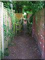
9
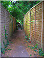
Footpath to Littlehampton Road
Linking Downview Avenue with the A259. Beyond the fences is the footbridge over Ferring Rife.
Image: © Simon Carey
Taken: 20 Jul 2008
0.09 miles
10
Footbridge over Ferring Rife
Opposite view to Image, taking the footpath from the A259 Littlehampton Road over the stream and onto Downview Avenue.
Image: © Simon Carey
Taken: 20 Jul 2008
0.09 miles