IMAGES TAKEN NEAR TO
Highdown Way, WORTHING, BN12 6QG
Introduction
This page details the photographs taken nearby to Highdown Way, BN12 6QG by members of the Geograph project.
The Geograph project started in 2005 with the aim of publishing, organising and preserving representative images for every square kilometre of Great Britain, Ireland and the Isle of Man.

There are currently over 7.5m images from over14,400 individuals and you can help contribute to the project by visiting https://www.geograph.org.uk
Image Map
Images are licensed for reuse under creativecommons.org/licenses/by-sa/2.0
Notes
- Clicking on the map will re-center to the selected point.
- The higher the marker number, the further away the image location is from the centre of the postcode.
Image Listing (98 Images Found)
Images are licensed for reuse under creativecommons.org/licenses/by-sa/2.0
Image
Details
Distance
1
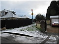
Footpath to Onslow Drive
Public footpath 2113 from route 700 bus stop in Langbury Lane.
Image: © Peter Holmes
Taken: 31 Jan 2015
0.05 miles
2
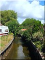
Ferring Rife
Looking north from Langbury Lane.
A small waterway that rises in Durrington and enters the sea via an outfall on the south western edge of Ferring parish. Rife is a local Sussex dialect word for a small river and the name is particularly numerous on the coastal plain between Worthing and Chichester. Ferring Rife is the eastern most example.
Image: © Simon Carey
Taken: 6 Aug 2017
0.05 miles
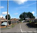
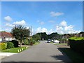
3
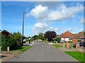
Cissbury Road, Ferring
A residential road that connects Highdown Way to Downsview Avenue that was built in the late 1950s with this section covering two former fields called Cornered Croft and Langbury Croft according to Ferring's 1837 tithe map.
Image: © Simon Carey
Taken: 6 Aug 2017
0.05 miles
4
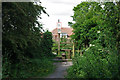
Footpath 2113, Ferring
Just south of the level crossing of the railway.
Image: © Robin Webster
Taken: 20 Jun 2010
0.06 miles
5
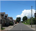
Langbury Lane, Ferring
An old route out of Ferring connecting it with Hangleton and Highdown Hill. This section was rerouted and straightened when the railway to the south was built.
Image: © Simon Carey
Taken: 6 Aug 2017
0.06 miles
6
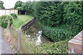
Ferring Rife at Langbury Lane
The rife has very clear water, as most chalk streams do, but this one has to make a passage through several potential sources of pollution.
Image: © Robin Webster
Taken: 20 Jun 2010
0.06 miles
7
West Onslow Close, Ferring
A cul de sac off Onslow Drive that was developed in the mid 1950s.
Image: © Simon Carey
Taken: 6 Aug 2017
0.08 miles
8
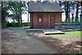
Pump house, Ferring
In a small compound surrounded by trees just south of the railway.
Image: © Robin Webster
Taken: 20 Jun 2010
0.08 miles
9
Downview Road, Ferring
A residential road built in the 1930 that heads north from Highdown Way and is also public footpath 2123.
Image: © Simon Carey
Taken: 13 Aug 2017
0.08 miles
10
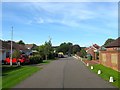
Highdown Way, Ferring
A cul de sac off Langbury Lane built in the 1950s on a former field called Common Meadow according to Ferring's 1837 tithe map.
Image: © Simon Carey
Taken: 6 Aug 2017
0.10 miles