IMAGES TAKEN NEAR TO
The Highway, PEACEHAVEN, BN10 8XL
Introduction
This page details the photographs taken nearby to The Highway, BN10 8XL by members of the Geograph project.
The Geograph project started in 2005 with the aim of publishing, organising and preserving representative images for every square kilometre of Great Britain, Ireland and the Isle of Man.

There are currently over 7.5m images from over14,400 individuals and you can help contribute to the project by visiting https://www.geograph.org.uk
Image Map
Images are licensed for reuse under creativecommons.org/licenses/by-sa/2.0
Notes
- Clicking on the map will re-center to the selected point.
- The higher the marker number, the further away the image location is from the centre of the postcode.
Image Listing (65 Images Found)
Images are licensed for reuse under creativecommons.org/licenses/by-sa/2.0
Image
Details
Distance
1
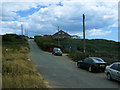
The Highway, Peacehaven
This unmade road links the A259 to houses on other unmade roads on Peacehaven and Harbour Heights.
Image: © Kevin Gordon
Taken: 20 Jul 2008
0.01 miles
2
Lighthouse Point, The Highway
There has been a house on this plot since the 1920s though I have a feeling this may be a rebuild.
Image: © Simon Carey
Taken: 6 Jul 2012
0.02 miles
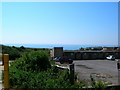
3
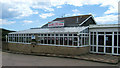
The Paradiso Coffee House, Peacehaven
This is shown on OS maps as a motel but this closed many years ago - the building was latterly used as a Coffee House but has closed and is awaiting redevelopment. Although the building fronts the busy A259 the rear has views over the English Channel.
Image: © Kevin Gordon
Taken: 20 Jul 2008
0.08 miles
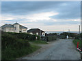
4
The Leas
The name of the track which was part of the original 1920s layout of Peacehaven Heights. Its planned course ran south from The Highway then turned west and ended at Cliff Road. The house on the right was built in the 1930s and is numbered 14 despite it being the only ever house built on the road. Beyond it the road becomes a greenway which follows the original course of the planned road. To the left are the static caravans of Rushy Hill Caravan Park.
Image: © Simon Carey
Taken: 6 Jul 2012
0.09 miles
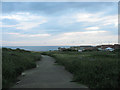
6
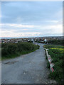
The Highway
Looking down towards its junction with South Coast Road, the A259, at the eastern end of Peacehaven. Now a restricted byway it was the original road to Newhaven across what was then open downland. The new route branching off to the right was added in the early 19th century when the road was turnpiked and lessened the gradient when negotiating Rushy Hill. The road is still used as an access route for the houses on Peacehaven Heights.
Image: © Simon Carey
Taken: 6 Jul 2012
0.10 miles
7
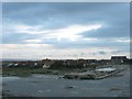
Remains of Peacehaven Motel
Image now demolished. The motel had actually ceased trading by the original picture and later became Image with the building finally knocked down a couple of years ago. What will replace it is still unknown, a block of flats was granted permission in 2006 but have yet to make an appearance. For a while there was a suggestion that a new fire station should be built here and there have also been rumours that Tesco are interested in the site. In the meantime the site has a rather forlorn look to it awaiting for something to happen to it.
Image: © Simon Carey
Taken: 6 Jul 2012
0.10 miles
8
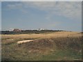
Further Denshire
The name of this piece of rough ground according to Piddinghoe's 1843 tithe map. When Charles Neville purchased much of the downland in the southern part of the former parish this was included and was laid out with roads, what would have been Cliff Road is the greenway to the left, but these were barely developed and after the Second World War when tougher planning regulations were introduced the undeveloped area known as Peacehaven Heights was left as a green corridor between Peacehaven and Newhaven. A number of houses dot the landscape and some of the old roads can still be made out by many others disappeared. The current cliff top between the two towns is open access and is a popular dog walking area.
Image: © Simon Carey
Taken: 6 Jul 2012
0.11 miles
9
Peacehaven Motel
Rather seedy looking rooms of the motel on the western edge of Peacehaven as the A259 leaves town. At least the back south facing windows have excellent views of the cliffs and sea.
Image: © Simon Carey
Taken: 30 Aug 2005
0.12 miles
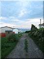
10
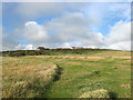
Cliff Road
Part of the original 1920s layout of Peacehaven Heights and named as such on the 1928 OS map. However, no plots were ever sold down this road and the road fell into abeyance and lost its designation after the Second World War. I'm not sure when the road was surfaced but it does not stretch down to the cliff top so I'm guessing possibly Second World War. The track is not a public right of way though many people walk down it. The house with the flat roof to the right was built on the site of a former chalk pit which for many years was the only feature marked on a map between the road and the sea.
Image: © Simon Carey
Taken: 6 Jul 2012
0.12 miles