IMAGES TAKEN NEAR TO
Cavell Avenue, PEACEHAVEN, BN10 8LG
Introduction
This page details the photographs taken nearby to Cavell Avenue, BN10 8LG by members of the Geograph project.
The Geograph project started in 2005 with the aim of publishing, organising and preserving representative images for every square kilometre of Great Britain, Ireland and the Isle of Man.

There are currently over 7.5m images from over14,400 individuals and you can help contribute to the project by visiting https://www.geograph.org.uk
Image Map
Images are licensed for reuse under creativecommons.org/licenses/by-sa/2.0
Notes
- Clicking on the map will re-center to the selected point.
- The higher the marker number, the further away the image location is from the centre of the postcode.
Image Listing (114 Images Found)
Images are licensed for reuse under creativecommons.org/licenses/by-sa/2.0
Image
Details
Distance
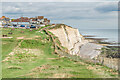
1

The Dell, Peacehaven
Recreation ground near the Cliffs at Peacehaven
Image: © Paul Gillett
Taken: 29 Sep 2012
0.04 miles
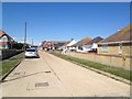
2
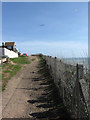
The Promenade
Cliff top road that begins at the western border of Peacehaven and ends at the eastern border and like many other roads in the towns split into sections having been broken up by two parks and a lack of roadway. This part is between The Dell and Roderick Avenue.
Image: © Simon Carey
Taken: 15 Mar 2009
0.05 miles
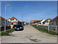
3
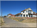
Roderick Avenue, Peacehaven
Roderick Avenue is a minor residential road leading to and from the clifftop at Peacehaven on the Sussex coast.
Image: © Malc McDonald
Taken: 24 Jul 2022
0.05 miles
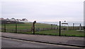
5
The Dell
Clifftop open space in Peacehaven, with houses on The Promenade in the background.
Image: © Ian Capper
Taken: 20 Sep 2022
0.06 miles
6
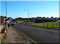
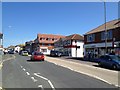
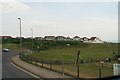
South Coast Road, Peacehaven
Originally known as Dover Road and is the main A259 road through the town. Other than Hoddern Farm and two coastguard cottages in Telscombe Cliffs the only thing one would have found in this square from the 19th century. The dip in the park on the right hand side is not actually a natural feature but comes courtesy of the Luftwaffe. This view looks east toward the roundabout.
Image: © Simon Carey
Taken: 25 Dec 2005
0.06 miles
7
Edith Avenue
Another road with many different sections. This part looks from the southern junction with The Promenade near the cliff top and looks towards the South Coast Road, the A259. It then continues northward to Arundel Road before being separated from its northern section between Balcombe Road and Firle Road by the Meridian Centre.
Image: © Simon Carey
Taken: 15 Mar 2009
0.07 miles
9
From Telscombe into Peacehaven on the A259 South Coast Road
Image: © Chris
Taken: 11 Jun 2016
0.07 miles