IMAGES TAKEN NEAR TO
Pine Street South, BURY, BL9 7BU
Introduction
This page details the photographs taken nearby to Pine Street South, BL9 7BU by members of the Geograph project.
The Geograph project started in 2005 with the aim of publishing, organising and preserving representative images for every square kilometre of Great Britain, Ireland and the Isle of Man.

There are currently over 7.5m images from over14,400 individuals and you can help contribute to the project by visiting https://www.geograph.org.uk
Image Map
Images are licensed for reuse under creativecommons.org/licenses/by-sa/2.0
Notes
- Clicking on the map will re-center to the selected point.
- The higher the marker number, the further away the image location is from the centre of the postcode.
Image Listing (78 Images Found)
Images are licensed for reuse under creativecommons.org/licenses/by-sa/2.0
Image
Details
Distance
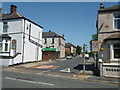
1
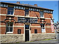
Bury: The 'Turf'
Appears to be apub that has been closed and then re-opened. But for how long?
Image: © Dr Neil Clifton
Taken: 4 Jun 2013
0.03 miles
2
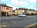
Myrtle Street South, Bury
Viewed across the A58 Rochdale Road.
Image: © Jaggery
Taken: 6 Oct 2013
0.03 miles
3
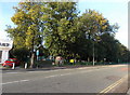
Northern edge of Openshaw Park, Bury
Viewed across the A58 Rochdale Road. Openshaw Park is a public park covering an area of c5 hectares in the Pimhole area, about a mile east of Bury town centre. The park opened in 1888.
Image: © Jaggery
Taken: 6 Oct 2013
0.07 miles
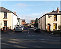
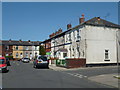
4
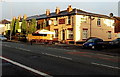
Roach Hotel, Bury
Pub at 331 Rochdale Road, on the corner of Deal Street.
Image: © Jaggery
Taken: 6 Oct 2013
0.07 miles
7
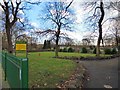
Openshaw Park
Openshaw Park is a local community public park of approximately 5 hectares. It is located just over a mile outside of Bury town centre in an area historically known as Pimhole. Openshaw Park was one of four parks established following a public meeting in 1883, with contributions from Lord Derby, the Lord of the Manor, a public subscription, and, in this particular case, generous contributions of land and money from a local benefactor, Mr Thomas O Openshaw. This and another three parks were opened by the Prince of Wales, HRH Prince Albert Victor, on 21 July 1888.
Its facilities include crown green bowling pavilion and greens, children's play area, two multi-play ball zones, one flood-lit and two flood-lit tennis courts.
More information is on the council website: http://www.bury.gov.uk/index.aspx?articleid=11202
Image: © Gerald England
Taken: 4 Feb 2017
0.08 miles
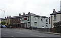
9
Rochdale Road, Pimhole
The A58 out of Bury. On the left is the Roach Hotel.
Image: © Gerald England
Taken: 4 Feb 2017
0.08 miles
10
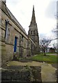
St Thomas's: Churchyard on north side
The Parish Church of St Thomas, at the corner of Pimhole Road and Rochdale Road, was a gift from Thomas Openshaw a local mill owner. Amongst other things, it was built to serve the rows of mill houses that surrounded the church. It is built in the mediaeval style or that period of Gothic architecture known as Early English and the Church spire rises to 120 feet. The Church was consecrated on the 10th December 1866 and the first vicar was Reverend Thomas Atherton.
Image: © Gerald England
Taken: 4 Feb 2017
0.08 miles