IMAGES TAKEN NEAR TO
Bolton Road, BURY, BL8 4HZ
Introduction
This page details the photographs taken nearby to Bolton Road, BL8 4HZ by members of the Geograph project.
The Geograph project started in 2005 with the aim of publishing, organising and preserving representative images for every square kilometre of Great Britain, Ireland and the Isle of Man.

There are currently over 7.5m images from over14,400 individuals and you can help contribute to the project by visiting https://www.geograph.org.uk
Image Map
Images are licensed for reuse under creativecommons.org/licenses/by-sa/2.0
Notes
- Clicking on the map will re-center to the selected point.
- The higher the marker number, the further away the image location is from the centre of the postcode.
Image Listing (10 Images Found)
Images are licensed for reuse under creativecommons.org/licenses/by-sa/2.0
Image
Details
Distance
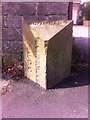
1
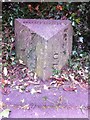
Old Boundary Marker by the A676, Bolton Road
Parish Boundary Marker by the A676, in parish of Bury (Bury District), Bolton Road; Greenmount, outside No 11.
Surveyed
Milestone Society National ID: LA_BORS05pb.
Image: © Milestone Society
Taken: Unknown
0.02 miles
2
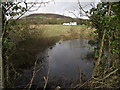
Pond at Holcombe Brook
Looking from the A676 on the boundary between Holcombe Brook and Hawkshaw. The white house in the mid ground is Redisher Farm, and in the background is the Peel Tower at Holcombe.
Image: © philandju
Taken: 21 Jan 2012
0.04 miles
3
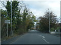
A676 Bolton Road at Holcombe Brook boundary
Image: © Colin Pyle
Taken: 21 Oct 2019
0.08 miles
4
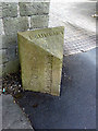
Boundary Stone Ramsbottom/Tottington UDC
Boundary stone at Greenmount / Holcombe Brook .
Image: © Cliff
Taken: 8 May 2013
0.19 miles
5
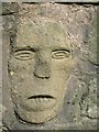
Frowning Face at Mount Pleasant
There are two carved stone faces incorporated into the garden wall of Mount Pleasant on Bolton Road.
Image: © Kevan Corr
Taken: 8 Apr 2007
0.19 miles
6
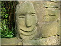
Smiling face at Mount Pleasant
Incorporated into the garden wall of Mount Pleasant on Bolton Road there are 2 carved faces, one smiles the other frowns.
Image: © Kevan Corr
Taken: 25 Mar 2007
0.19 miles
8
Brandlesholme Road
At the boundary between Greenmount and Holcombe Brook and looking towards the Peel Tower.
Image: © philandju
Taken: 21 Jan 2012
0.19 miles
9
Old Boundary Marker by the B6215, Holcombe Road, Bury parish
Parish Boundary Marker by the B6215, in parish of Bury (Bury District), Holcombe Road; Greenmount, opposite No 510.
Defaced inscription reads:-
: (??) / U.D.C. : : BOUNDARY : : (??) / U.D.C. :
Surveyed
Milestone Society National ID: LA_BYBB02pb
Image: © Milestone Society
Taken: Unknown
0.20 miles
10
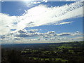
Redisher to Manchester
Taken on the path running above Saplin Wood and Fine Brows across Redisher Wood Nature Reserve, I am looking across the Greater Manchester conurbation to Bury, Manchester and Salford. The Peak District can be glimpsed on the far horizon to the left of shot.
Image: © Carroll Pierce
Taken: 10 Oct 2016
0.21 miles