IMAGES TAKEN NEAR TO
Old Kays, BURY, BL8 3PZ
Introduction
This page details the photographs taken nearby to Old Kays, BL8 3PZ by members of the Geograph project.
The Geograph project started in 2005 with the aim of publishing, organising and preserving representative images for every square kilometre of Great Britain, Ireland and the Isle of Man.

There are currently over 7.5m images from over14,400 individuals and you can help contribute to the project by visiting https://www.geograph.org.uk
Image Map
Images are licensed for reuse under creativecommons.org/licenses/by-sa/2.0
Notes
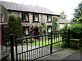
- Clicking on the map will re-center to the selected point.
- The higher the marker number, the further away the image location is from the centre of the postcode.
Image Listing (14 Images Found)
Images are licensed for reuse under creativecommons.org/licenses/by-sa/2.0
Image
Details
Distance
2
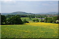
Buttercup slopes
This is taken from the northerly tip of Tottington, looking north east. Greenmount URC is prominent to the right, while Holly Mount is visible in the trees to the left. Straight ahead is Holcombe Moor with Peel Tower.
Image: © Bill Boaden
Taken: 5 Jun 2010
0.09 miles
3
Farmland below Turton Road
Sheep are grazing in Two Brooks Valley. Beyond that are Greenmount and Holcombe Hill, while Scout Moor is in the far background.
Image: © Bill Boaden
Taken: 25 Oct 2020
0.11 miles
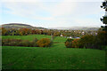
4
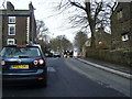
Holcombe Road, Stormer Hill (Temporary traffic lights)
Image: © Colin Pyle
Taken: 23 Mar 2010
0.17 miles
5
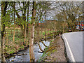
Kirklees Brook near Brookhouse Mill
Kirklees Brook springs from the slopes of Holcombe Moor at Grainings, north of Hawkshaw, flowing south for approx. 6½ miles before joining the River Irwell in the Woodhill area of Bury. At Brookhouse Mill between Greenmount and Tottington, there are a number of small connected reservoirs.
Image: © David Dixon
Taken: 8 Apr 2021
0.20 miles
7
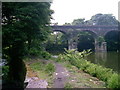
Bridge over troubled waters
Fishing, walking and anything else.
Image: © m0sgb
Taken: 17 Jun 2006
0.21 miles
8
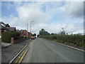
Turton Road, Tottington
Looking north west on the B6213.
Image: © JThomas
Taken: 17 Sep 2018
0.21 miles
9
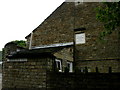
House Stormer Hill
Plaque reads Smalley Edward and Ellen 1759
Image: © liz dawson
Taken: 16 Jun 2007
0.21 miles
10
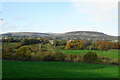
Two Brooks Valley
In the background is Holcombe Moor, with the highest point, Bull Hill, at the back and centre.
Image: © Bill Boaden
Taken: 25 Oct 2020
0.21 miles