IMAGES TAKEN NEAR TO
Vale Street, BOLTON, BL7 0DY
Introduction
This page details the photographs taken nearby to Vale Street, BL7 0DY by members of the Geograph project.
The Geograph project started in 2005 with the aim of publishing, organising and preserving representative images for every square kilometre of Great Britain, Ireland and the Isle of Man.

There are currently over 7.5m images from over14,400 individuals and you can help contribute to the project by visiting https://www.geograph.org.uk
Image Map
Images are licensed for reuse under creativecommons.org/licenses/by-sa/2.0
Notes
- Clicking on the map will re-center to the selected point.
- The higher the marker number, the further away the image location is from the centre of the postcode.
Image Listing (33 Images Found)
Images are licensed for reuse under creativecommons.org/licenses/by-sa/2.0
Image
Details
Distance
1
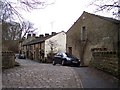
Cobbles in Birches Road at Turton Bottoms
Image: © Raymond Knapman
Taken: 14 Feb 2011
0.03 miles
3
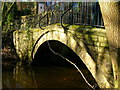
Pack Saddles Bridge
Pack Saddles Bridge today functions as a footbridge carrying the Witton Weavers Way over Bradshaw Brook. As its name suggests, however, it has a long history and dates from the late 17th century.
Image: © John H Darch
Taken: 2 Feb 2007
0.03 miles
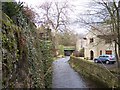
4
Turton Bottoms
On the edge of Edgworth. The bridge in the foreground is Turton Bottoms Bridge (widened 1901) and the bistro beyond is Olive's Bistro and Wine Bar. The hostelry was previously known as the Spread Eagle.
Image: © philandju
Taken: 6 Jan 2012
0.05 miles
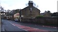
5
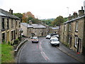
Bolton Road Edgworth
Stone cottages line both sides of the road on this sharp bend in Edgworth.
Most of the buildings lining the road are of the early 1800s and include the strange names of Kettle Row,Teapot Row and Grubb Street.
For future reference the two bedroom cottage on the left hand side was on the market for £139,950 in September 2007.
Image: © Paul Anderson
Taken: 23 Sep 2007
0.08 miles
6
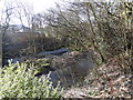
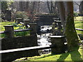
River by Vale Street
The river runs past the gardens of Vale Street, Turton Bottoms.
Image: © Alan Hawkes
Taken: 17 Feb 2013
0.09 miles
7
Brook runs through housing estate at Turton Bottoms
Image: © Raymond Knapman
Taken: 25 May 2015
0.11 miles
8
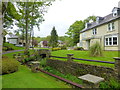
Holcombe Moor from Turton Tower
Taken in the gardens of Turton Tower, north of Bolton in Lancashire, Holcombe Moor, with the Peel Monument and Harcles and Bull Hills on the horizon.
Image: © Carroll Pierce
Taken: 16 Jul 2014
0.12 miles
9
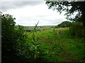
Turton Bottoms
Water from Wayoh to Jumbles travels along here
The reservoir was built as a compensation reservoir in 1876 to ensure a continuous flow of water into Bradshaw Brook - so essential to feed the several bleach works down stream at that time. It is now used for domestic supply and another compensation reservoir has been built down stream in the Jumbles.
http://www.lancashire.gov.uk/environment/countryside/walking/edgworth.asp
Image: © liz dawson
Taken: 25 Mar 2007
0.12 miles
10
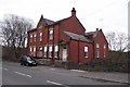
Former Conservative Club
On Wellington Road near Turton Bottoms. The building was erected in 1904 and opened on 14 May in that year by The Right Honourable Lord Stanley, the then Post Master General. The building now stands empty.
Image: © philandju
Taken: 22 Apr 2013
0.17 miles