IMAGES TAKEN NEAR TO
Maple Close, BOLTON, BL4 8LW
Introduction
This page details the photographs taken nearby to Maple Close, BL4 8LW by members of the Geograph project.
The Geograph project started in 2005 with the aim of publishing, organising and preserving representative images for every square kilometre of Great Britain, Ireland and the Isle of Man.

There are currently over 7.5m images from over14,400 individuals and you can help contribute to the project by visiting https://www.geograph.org.uk
Image Map
Images are licensed for reuse under creativecommons.org/licenses/by-sa/2.0
Notes
- Clicking on the map will re-center to the selected point.
- The higher the marker number, the further away the image location is from the centre of the postcode.
Image Listing (8 Images Found)
Images are licensed for reuse under creativecommons.org/licenses/by-sa/2.0
Image
Details
Distance
3
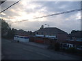
The "Spar" owned for over 30 years by John Roberts
Photo taken in the summer of 2006
Image: © Jamie Roberts
Taken: 15 Jul 2006
0.16 miles
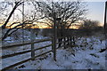
4
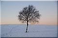
Solitary birch tree at Manor Golf Club
The snow cover made it hard to discern the golf course.
Image: © Bill Boaden
Taken: 24 Dec 2010
0.19 miles
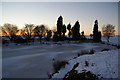
5
Bent Spur Road
This runs from Manor Golf Club and an unnamed farm to join the A666 by St Stephen's Church in Kearsley Moor.
Image: © Bill Boaden
Taken: 24 Dec 2010
0.22 miles
6
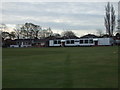
Kearsley Cricket Club - Pavilion
The Pavilion and changing rooms at Kearsley CC. The club run two teams in the Bolton Cricket League.
Image: © BatAndBall
Taken: 3 May 2013
0.22 miles
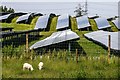
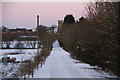
7
Path junction by the M61
A sliproad off the Kearsley Spur of the M61 is the nearest road to the left. Paths are hard to discern in the snow, but you follow where everyone else has been.
Image: © Bill Boaden
Taken: 24 Dec 2010
0.23 miles
8
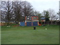
Kearsley Cricket Club - Scoreboard
The scoreboard at Kearsley CC.
Image: © BatAndBall
Taken: 3 May 2013
0.25 miles