IMAGES TAKEN NEAR TO
Newmarket Road, BOLTON, BL3 1TA
Introduction
This page details the photographs taken nearby to Newmarket Road, BL3 1TA by members of the Geograph project.
The Geograph project started in 2005 with the aim of publishing, organising and preserving representative images for every square kilometre of Great Britain, Ireland and the Isle of Man.

There are currently over 7.5m images from over14,400 individuals and you can help contribute to the project by visiting https://www.geograph.org.uk
Image Map
Images are licensed for reuse under creativecommons.org/licenses/by-sa/2.0
Notes
- Clicking on the map will re-center to the selected point.
- The higher the marker number, the further away the image location is from the centre of the postcode.
Image Listing (82 Images Found)
Images are licensed for reuse under creativecommons.org/licenses/by-sa/2.0
Image
Details
Distance
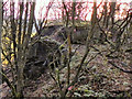
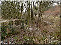
2
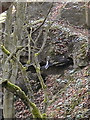
Manchester, Bolton & Bury Canal; Breach
The remains of the canal wall and embankment on the southern side of the canal, where it was breached in 1936.
This picture gives an impression of the high quality massive construction of the canal wall and railway lines that had been used to reinforce the steep embankment can still be seen sticking out from the remains.
(http://www.boltonmuseums.org.uk/collections/local-history/archivesimages02/1940loc?term=photograph&s_tags=&sort_by=Title&item_number=393&b_start:int=0 and http://www.boltonmuseums.org.uk/collections/local-history/archivesimages02/1941loc?term=photograph&s_tags=&sort_by=Title&item_number=394&b_start:int=0 contemporary photographs in Bolton Museum archives
http://www.penninewaterways.co.uk/mbb/mbbc30.htm another contemporary photograph from the John and Margaret Fletcher Collection)
Image: © David Dixon
Taken: 14 Nov 2010
0.14 miles
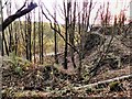
3
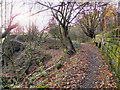
Manchester, Bolton & Bury Canal; Site of the 1936 Breach
Looking west, past the site of the breach. The path here is following the canal bed. To the left, the towpath and embankment were swept away in 1936. On the right hand side, the massive canal wall is still clearly evident.
Image: © David Dixon
Taken: 14 Nov 2010
0.14 miles
4
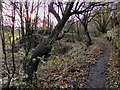
Manchester, Bolton & Bury Canal
Looking west, past the site of the breach. The path here follows the canal bed. To the left, the towpath and embankment were swept away in 1936. The canal wall is still evident on the right hand side.
Image: © David Dixon
Taken: 14 Nov 2010
0.14 miles
5
Manchester Bolton & Bury Canal, Site of 1936 Breach
The site of the breach, a short way east of the Nob End locks.
Looking west from the canal bed, into the breach, which occurred on 6th July 1936, draining the canal of all its water. In the breach you can see the high quality massive construction of the canal wall and railway lines that had been used to reinforce the steep embankment can still be seen sticking out from the remains.
(http://www.boltonmuseums.org.uk/collections/local-history/archivesimages02/1940loc?term=photograph&s_tags=&sort_by=Title&item_number=393&b_start:int=0 and http://www.boltonmuseums.org.uk/collections/local-history/archivesimages02/1941loc?term=photograph&s_tags=&sort_by=Title&item_number=394&b_start:int=0 contemporary photographs in Bolton Museum archives
http://www.penninewaterways.co.uk/mbb/mbbc30.htm another contemporary photograph from the John and Margaret Fletcher Collection)
Image: © David Dixon
Taken: 14 Nov 2010
0.14 miles
6
Manchester, Bolton & Bury Canal; Site of Breach
The site of the breach, a short way east of the Nob End locks.
Looking west from the canal bed, into the breach, which occurred on 6th July 1936, draining the canal of all its water. Railway lines that had been used to reinforce the steep embankment can still be seen sticking out from the remains.
(http://www.boltonmuseums.org.uk/collections/local-history/archivesimages02/1940loc?term=photograph&s_tags=&sort_by=Title&item_number=393&b_start:int=0 and http://www.boltonmuseums.org.uk/collections/local-history/archivesimages02/1941loc?term=photograph&s_tags=&sort_by=Title&item_number=394&b_start:int=0 contemporary photographs in Bolton Museum archives
http://www.penninewaterways.co.uk/mbb/mbbc30.htm another contemporary photograph from the John and Margaret Fletcher Collection)
Image: © David Dixon
Taken: 14 Nov 2010
0.14 miles
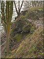
7
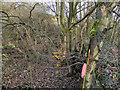
Manchester, Bolton & Bury Canal, Nob End
In 1936, a short way east of the Nob End locks, the towpath was swept away when the canal was breached; the path now has to descend into the canal bed to skirt the breach.
At this point, a bend of the River Irwell has eroded the valley side into a steep slope. The canal wound round the hillside, over 100 feet above the valley floor. It was supported by massive brick retaining walls, mostly constructed in the 1890s, with a sheer drop from the towpath. The breach occurred on 6th July 1936, and water pressure carried away 20 yards of towpath and canal wall, depositing them in the valley below. When the breach happened, it was so sudden that it swept two boats down into the river below and quickly drained the canal of all its water.
(http://www.boltonmuseums.org.uk/collections/local-history/archivesimages02/1940loc?term=photograph&s_tags=&sort_by=Title&item_number=393&b_start:int=0 and http://www.boltonmuseums.org.uk/collections/local-history/archivesimages02/1941loc?term=photograph&s_tags=&sort_by=Title&item_number=394&b_start:int=0 contemporary photographs in Bolton Museum archives
http://www.penninewaterways.co.uk/mbb/mbbc30.htm another contemporary photograph from the John and Margaret Fletcher Collection)
The breach was not repaired because there wasn’t any through traffic, and the whole area has since become overgrown with trees.
Image: © David Dixon
Taken: 14 Nov 2010
0.15 miles
8
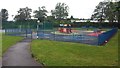
Mytham Park Play Area
The park is on the opposite side of Mytham Road to Mytham Primary School
Image: © Bradley Michael
Taken: 14 Aug 2015
0.15 miles
9
Breach Site, Manchester, Bolton and Bury Canal
Looking west, past the site where the towpath and embankment were swept away when the canal was breached in 1936, a short way to the east of Nob End Locks.
This picture gives an impression of the high quality massive construction of the canal wall and railway lines that had been used to reinforce the steep embankment can still be seen sticking out from the remains.
(http://www.boltonmuseums.org.uk/collections/local-history/archivesimages02/1940loc?term=photograph&s_tags=&sort_by=Title&item_number=393&b_start:int=0 and http://www.boltonmuseums.org.uk/collections/local-history/archivesimages02/1941loc?term=photograph&s_tags=&sort_by=Title&item_number=394&b_start:int=0 contemporary photographs in Bolton Museum archives
http://www.penninewaterways.co.uk/mbb/mbbc30.htm another contemporary photograph from the John and Margaret Fletcher Collection)
Image: © David Dixon
Taken: 12 Dec 2012
0.15 miles
10
Manchester, Bolton and Bury Canal, Site of Breach
Looking west at the site where the towpath and embankment were swept away when the canal was breached in 1936, a short way to the east of Nob End Locks.
This picture gives an impression of the high quality massive construction of the canal wall and railway lines that had been used to reinforce the steep embankment can still be seen sticking out from the remains.
(http://www.boltonmuseums.org.uk/collections/local-history/archivesimages02/1940loc?term=photograph&s_tags=&sort_by=Title&item_number=393&b_start:int=0 and http://www.boltonmuseums.org.uk/collections/local-history/archivesimages02/1941loc?term=photograph&s_tags=&sort_by=Title&item_number=394&b_start:int=0 contemporary photographs in Bolton Museum archives
http://www.penninewaterways.co.uk/mbb/mbbc30.htm another contemporary photograph from the John and Margaret Fletcher Collection)
Image: © David Dixon
Taken: 12 Dec 2012
0.15 miles