IMAGES TAKEN NEAR TO
Shelley Walk, BOLTON, BL1 3XQ
Introduction
This page details the photographs taken nearby to Shelley Walk, BL1 3XQ by members of the Geograph project.
The Geograph project started in 2005 with the aim of publishing, organising and preserving representative images for every square kilometre of Great Britain, Ireland and the Isle of Man.

There are currently over 7.5m images from over14,400 individuals and you can help contribute to the project by visiting https://www.geograph.org.uk
Image Map (Loading...)


Getting Data...Please wait
Leaflet Map data © OpenStreetMap
Images are licensed for reuse under creativecommons.org/licenses/by-sa/2.0
Notes
- Clicking on the map will re-center to the selected point.
- The higher the marker number, the further away the image location is from the centre of the postcode.
Image Listing (13 Images Found)
Images are licensed for reuse under creativecommons.org/licenses/by-sa/2.0
Image
Details
Distance
1
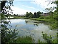
Fishing lodge
An industrial reservoir probably for the demolished Mortfield Bleach Works at Brownlow Fold
Image: © Kevin Waterhouse
Taken: 20 Jun 2024
0.08 miles
3
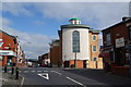
Makki Mosque, Eskrick Street
Rebuilt around an older building.
Image: © Bill Boaden
Taken: 15 Sep 2012
0.16 miles
4
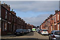
Arnold Street, Halliwell
A traditional terraced and cobbled street, updated with cars and satellite dishes.
Image: © Bill Boaden
Taken: 15 Sep 2012
0.18 miles
5
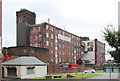
Brownlow Fold Mills - 1
The nearer building was an extension to No.1 Mill, the rest of which, nearer the camera, was demolished in 1961. The further building is No.2 Mill, dating from 1905. The mills now house smaller industrial units.
Image: © Alan Murray-Rust
Taken: 25 Jul 2012
0.18 miles
6
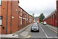
Lytton Street, Brownlow Fold
A reminder of the days when many people lived literally across the road from their place of work.
Image: © Alan Murray-Rust
Taken: 25 Jul 2012
0.18 miles
7
Brownlow Fold Mills - 2
No.3 mill, of 1907, consisted principally of a large weaving shed. The fact that it was latterly a postal sorting office probably explains the red paint.
Image: © Alan Murray-Rust
Taken: 25 Jul 2012
0.18 miles
8
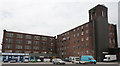
Brownlow Fold Mills - 3
No.2 Mill (left) and the remaining portion of No.1 Mill, which formerly occupied the foreground car park.
Image: © Alan Murray-Rust
Taken: 25 Jul 2012
0.20 miles
9
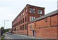
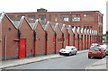
Brownlow Fold Mills - 4
No.3 mill, of 1907, consisted principally of a large weaving shed. The 3-storey section on Tennyson Street seen here would have contained preparation and finishing processes for the weaving section.
Image: © Alan Murray-Rust
Taken: 25 Jul 2012
0.20 miles
10
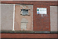
Mill Improvement Programme
The first flush of funding has clearly been exhausted. (Part of the Darley Street frontage of Brownlow Fold Mill No.2)
Image: © Alan Murray-Rust
Taken: 25 Jul 2012
0.21 miles