IMAGES TAKEN NEAR TO
Newlea Close, BOLTON, BL1 3JP
Introduction
This page details the photographs taken nearby to Newlea Close, BL1 3JP by members of the Geograph project.
The Geograph project started in 2005 with the aim of publishing, organising and preserving representative images for every square kilometre of Great Britain, Ireland and the Isle of Man.

There are currently over 7.5m images from over14,400 individuals and you can help contribute to the project by visiting https://www.geograph.org.uk
Image Map
Images are licensed for reuse under creativecommons.org/licenses/by-sa/2.0
Notes
- Clicking on the map will re-center to the selected point.
- The higher the marker number, the further away the image location is from the centre of the postcode.
Image Listing (36 Images Found)
Images are licensed for reuse under creativecommons.org/licenses/by-sa/2.0
Image
Details
Distance
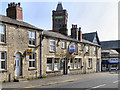
2
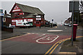
The Crofters Arms
Stone-built pub rubbing shoulders with the terraced cottages of the mill workers it would have served.
Image: © Alan Murray-Rust
Taken: 25 Jul 2012
0.16 miles
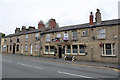
3
The Crofters Arms, Halliwell
A pub up for sale on Halliwell Road, with Falcon Mill behind it.
Image: © Bill Boaden
Taken: 15 Sep 2012
0.16 miles
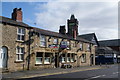
4
St Paul's Community Centre
A former church school erected in 1847. St Paul's Church is just beyond it.
Image: © Bill Boaden
Taken: 15 Sep 2012
0.16 miles
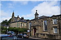
5
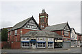
Former Co-op store, Halliwell
Despite varied architectural styles, former Co-op stores are often immediately identifiable as such. The panel over the entrance carries the beehive and wheatsheaf emblems of the local Society, with the motto Industry and Thrift.
The tower of Falcon Mill behind is a reminder of the source of earlier local economic activity.
Image: © Alan Murray-Rust
Taken: 25 Jul 2012
0.16 miles
7
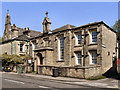
St Paul's Community Centre, Halliwell Road
Built as St Paul's School in 1847.
Image: © David Dixon
Taken: 19 Apr 2011
0.16 miles
8
St Paul's Community Centre
Built as St Paul's School in 1847.
Image: © David Dixon
Taken: 19 Apr 2011
0.16 miles
9
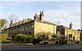
St. Paul's Place, Halliwell
St. Paul's Place in Halliwell consists of two terraces of stone cottages, one on each side of St. Paul's Church. This is the eastern terrace. The building to the right is now St. Paul's Community Centre. Built in 1847, it was originally a school.
Image: © philandju
Taken: 2 Dec 2014
0.16 miles
10
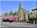
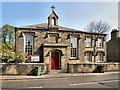
St Paul's Parish Church, Halliwell Road
Image: © David Dixon
Taken: 19 Apr 2011
0.17 miles