IMAGES TAKEN NEAR TO
Greenway Mews, BURY, BL0 9QW
Introduction
This page details the photographs taken nearby to Greenway Mews, BL0 9QW by members of the Geograph project.
The Geograph project started in 2005 with the aim of publishing, organising and preserving representative images for every square kilometre of Great Britain, Ireland and the Isle of Man.

There are currently over 7.5m images from over14,400 individuals and you can help contribute to the project by visiting https://www.geograph.org.uk
Image Map (Loading...)


Getting Data...Please wait
Leaflet Map data © OpenStreetMap
Images are licensed for reuse under creativecommons.org/licenses/by-sa/2.0
Notes
- Clicking on the map will re-center to the selected point.
- The higher the marker number, the further away the image location is from the centre of the postcode.
Image Listing (15 Images Found)
Images are licensed for reuse under creativecommons.org/licenses/by-sa/2.0
Image
Details
Distance
1
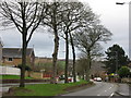
Nuttall Lane Ramsbottom
What looks like a main dual carriageway road out of Ramsbottom Nuttall Lane is just part of a loop road for the Whitingham Drive housing estate.
Image: © Paul Anderson
Taken: 13 Jan 2007
0.12 miles
2
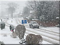
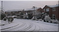
Nuttall Lane Ramsbottom
Taken during adverse weather conditions in December 2009 as snow continued to fall in the area for the third consecutive day causing many local roads to become impassable.
The lack of gritting by the Bury Metropolitan Borough Council was evident as local bus services which use Nuttall Lane were suspended.
Image: © Paul Anderson
Taken: 22 Dec 2009
0.15 miles
3
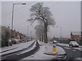
Nuttall Lane Ramsbottom
Taken on New Years Eve 2008 when temperatures dipped to minus 5 this is Nuttall Lane which looks like the main dual carriageway route out of Ramsbottom.
In fact it is nothing more than part of the circular loop road that only serves the Whittingham Drive Housing Estate.
With a 30mph speed limit someone should tell the local boy racers as they use this section of road as a race track in the evenings and weekends.
During 2008 this section of Nuttall Lane was the scene of three serious accidents which all occurred late at night.
Image: © Paul Anderson
Taken: 31 Dec 2008
0.15 miles
4
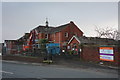
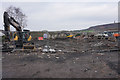
The demolition begins
Planning permission has been granted for about a year for the demolition of Ramsbottom Cottage Hospital. In the meantime, a new developer has acquired the land and revised plans have been approved. Finally the work is starting to go ahead.
Image: © Bill Boaden
Taken: 15 Feb 2015
0.17 miles
5
Cleared site on Nuttall Lane
This was until recently the site of Ramsbottom Cottage Hospital. It is expected to be occupied by 13 executive homes fairly soon.
Image: © Bill Boaden
Taken: 14 Mar 2015
0.18 miles
6
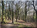
Broad Hey Wood Ramsbottom
This well used pathway through the woods is a popular spot for local dog walkers and mountain bikers.
For more information about the history of Ramsbottom click on http://web.archive.org/web/20051218151821/http://www.ramsbottom.net/history.htm
Image: © Paul Anderson
Taken: 11 Apr 2007
0.18 miles
7
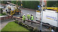
Men at Work
Engineers from BT install a new telegraph pole on Nuttall Lane in Ramsbottom.
This is the aftermath of an accident which involved a van losing control and mounting the pavement.
Not only did it severely damage the telegraph pole but also demolished the lamp post on the right that has also had to be replaced.
Image: © Paul Anderson
Taken: 3 Oct 2008
0.19 miles
8
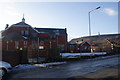
Ramsbottom Cottage Hospital
Suddenly visible after the removal of the trees which screened it. The only visibility issue now is the low winter sun. The NHS has decided it doesn't need this facility. It looks like proposals to refurbish and develop the existing building which dates from 1898 are not viable. Is demolition the only option? This option comes before the Planning Authority in April 2013.
Image: © Bill Boaden
Taken: 27 Jan 2013
0.19 miles
9
Nuttall Close Ramsbottom
Nuttall Close is located just off Nuttall Lane in Ramsbottom.
This photograph was taken on New Years Eve 2008 when temperatures in the area dipped to -5.
The close is made up of mainly 3 bedroom semi detached houses built in the mid 1970s.
For future reference one of these houses was on the market for £142,500 in December 2008.
Image: © Paul Anderson
Taken: 31 Dec 2008
0.21 miles
10
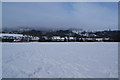
Bolton Road Playing Fields
This is the site of a former tip, which has been reclaimed for a Bury Council leisure facility. The methane issue appears to have subsided. Ahead you can normally see Holcombe Hill but it is obscured by cloud. To the right is Emmanuel Church, Holcombe.
Image: © Bill Boaden
Taken: 5 Feb 2012
0.21 miles