IMAGES TAKEN NEAR TO
Whittingham Drive, BURY, BL0 9NY
Introduction
This page details the photographs taken nearby to Whittingham Drive, BL0 9NY by members of the Geograph project.
The Geograph project started in 2005 with the aim of publishing, organising and preserving representative images for every square kilometre of Great Britain, Ireland and the Isle of Man.

There are currently over 7.5m images from over14,400 individuals and you can help contribute to the project by visiting https://www.geograph.org.uk
Image Map (Loading...)


Getting Data...Please wait
Leaflet Map data © OpenStreetMap
Images are licensed for reuse under creativecommons.org/licenses/by-sa/2.0
Notes
- Clicking on the map will re-center to the selected point.
- The higher the marker number, the further away the image location is from the centre of the postcode.
Image Listing (16 Images Found)
Images are licensed for reuse under creativecommons.org/licenses/by-sa/2.0
Image
Details
Distance
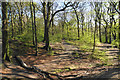
1
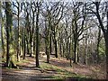
Broad Hey Wood Ramsbottom
This well used pathway through the woods is a popular spot for local dog walkers and mountain bikers.
For more information about the history of Ramsbottom click on http://web.archive.org/web/20051218151821/http://www.ramsbottom.net/history.htm
Image: © Paul Anderson
Taken: 11 Apr 2007
0.14 miles
2
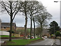
Nuttall Lane Ramsbottom
What looks like a main dual carriageway road out of Ramsbottom Nuttall Lane is just part of a loop road for the Whitingham Drive housing estate.
Image: © Paul Anderson
Taken: 13 Jan 2007
0.16 miles
3
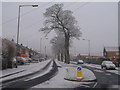
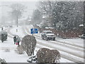
Nuttall Lane Ramsbottom
Taken on New Years Eve 2008 when temperatures dipped to minus 5 this is Nuttall Lane which looks like the main dual carriageway route out of Ramsbottom.
In fact it is nothing more than part of the circular loop road that only serves the Whittingham Drive Housing Estate.
With a 30mph speed limit someone should tell the local boy racers as they use this section of road as a race track in the evenings and weekends.
During 2008 this section of Nuttall Lane was the scene of three serious accidents which all occurred late at night.
Image: © Paul Anderson
Taken: 31 Dec 2008
0.17 miles
4
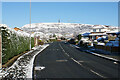
Whittingham Drive
The main artery of the Broad Hey estate. Peel Tower stands on Holcombe Hill directly ahead. This is a bright April morning.
Image: © Bill Boaden
Taken: 11 Apr 2021
0.17 miles
5
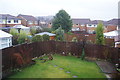
Suburban gardens on a wet New Year's Day
A collection of photographs taken around noon on New Year's Day 2014 by Geographers from all over Great Britain, Ireland and the Isle of Man.
Image: © Bill Boaden
Taken: 1 Jan 2014
0.18 miles
6
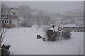
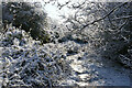
Snowstorm in Ramsbottom
The earlier stages of a sustained snowstorm. the strong winds caused a lot of drifting.
Image: © Bill Boaden
Taken: 28 Feb 2018
0.18 miles
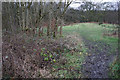
7
Woodland route of the back path
The "back path" is a tarmac path along the western edge of the Broadhey estate. This is an alternative parallel route through part of Broad Hey Wood, which can be much more attractive but also very muddy when wet. The spring greenery is just developing here.
Image: © Bill Boaden
Taken: 19 Apr 2020
0.19 miles
8
Muddy path behind the houses
You have to get out at this time of year, but the conditions are not particularly inviting.
Image: © Bill Boaden
Taken: 1 Jan 2018
0.21 miles
9
Nuttall Lane Ramsbottom
Taken during adverse weather conditions in December 2009 as snow continued to fall in the area for the third consecutive day causing many local roads to become impassable.
The lack of gritting by the Bury Metropolitan Borough Council was evident as local bus services which use Nuttall Lane were suspended.
Image: © Paul Anderson
Taken: 22 Dec 2009
0.21 miles
10
Footpath on the edge of the Broad Hey Estate
The estate is to the left and the land drops down to Summerseat to the right, though the view once available down to Summerseat has now been blocked by foliage. This is a bright April morning after a surprising amount of overnight snow.
Image: © Bill Boaden
Taken: 11 Apr 2021
0.23 miles