IMAGES TAKEN NEAR TO
Frederick Street, BURY, BL0 9NX
Introduction
This page details the photographs taken nearby to Frederick Street, BL0 9NX by members of the Geograph project.
The Geograph project started in 2005 with the aim of publishing, organising and preserving representative images for every square kilometre of Great Britain, Ireland and the Isle of Man.

There are currently over 7.5m images from over14,400 individuals and you can help contribute to the project by visiting https://www.geograph.org.uk
Image Map (41 Images)


Getting Data...Please wait
Leaflet Map data © OpenStreetMap
Images are licensed for reuse under creativecommons.org/licenses/by-sa/2.0
Notes
- Clicking on the map will re-center to the selected point.
- The higher the marker number, the further away the image location is from the centre of the postcode.
Image Listing (41 Images Found)
Images are licensed for reuse under creativecommons.org/licenses/by-sa/2.0
Image
Details
Distance
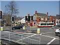
2
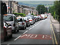
Traffic on Bolton Road West Ramsbottom
In July 2008 for a period of five weeks roadworks took place at the junction of Bolton Road West and Nuttall Lane in Ramsbottom.
The normal traffic lights at this busy junction had been turned off for the duration of the roadworks and replaced with temporary lights with no sensors controlling the traffic flow.
This resulted in chaos, which is seen in the picture above, every morning and evening with massive tailbacks in both directions on the A676.
Image
Image: © Paul Anderson
Taken: 8 Aug 2008
0.04 miles
3
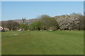
Bolton Road West Recreation Ground
Also known as the Top Field. This was a former tip and it is still surrounded by methane monitors. It is now a playing field. The tower of St Andrew's Church can be seen as well as some spring blossom.
Image: © Bill Boaden
Taken: 19 Apr 2020
0.05 miles
5
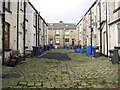
Wheelie Bin Lane Ramsbottom
Rear of Edgar Street on the left and the rear of Nuttall Lane on the right.
Some days you can't see this street for all the washing hung out between the houses.
Image: © Paul Anderson
Taken: 18 Jan 2007
0.12 miles
6
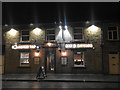
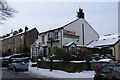
Holcombe Tap
A rebranding following refurbishment of the former Masons Arms.
Image: © Bill Boaden
Taken: 5 Oct 2018
0.12 miles
7
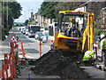
Bolton Road West Ramsbottom
In July 2008 for a period of five weeks roadworks took place at the junction of Bolton Road West and Nuttall Lane in Ramsbottom.
The normal traffic lights at this busy junction had been turned off for the duration of the roadworks and replaced with temporary lights with no sensors controlling the traffic flow.
This resulted in chaos every morning and evening with massive tailbacks in both directions on the A676.
Image
Image: © Paul Anderson
Taken: 8 Aug 2008
0.12 miles
8
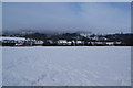
Bolton Road Playing Fields
This is the site of a former tip, which has been reclaimed for a Bury Council leisure facility. The methane issue appears to have subsided. Ahead you can normally see Holcombe Hill but it is obscured by cloud. To the right is Emmanuel Church, Holcombe.
Image: © Bill Boaden
Taken: 5 Feb 2012
0.12 miles
9
The Fusilier, Ramsbottom
A pub favoured by some of the younger generations.
Image: © Bill Boaden
Taken: 5 Feb 2012
0.15 miles
10
Old Dun Horse and Junction
At peak times this junction at Bolton Road West ,Nuttall Lane and Dundee Lane is very busy with traffic queues back to Ramsbottom centre.
Since 1843 there has been an annual exhibition, held on New Years Day, of game fowl organised by the Holcombe Old English Game Fowl Club.
This competitive show replaced the annual cockfight that took place in the town square following the New Year Holcombe Hunt.
The oldest gamecock show in the world, it is now held every year at the Old Dun Horse Hotel on the corner.
Image: © Paul Anderson
Taken: 27 Mar 2007
0.16 miles