IMAGES TAKEN NEAR TO
Nuttall Lane, BURY, BL0 9JZ
Introduction
This page details the photographs taken nearby to Nuttall Lane, BL0 9JZ by members of the Geograph project.
The Geograph project started in 2005 with the aim of publishing, organising and preserving representative images for every square kilometre of Great Britain, Ireland and the Isle of Man.

There are currently over 7.5m images from over14,400 individuals and you can help contribute to the project by visiting https://www.geograph.org.uk
Image Map (Loading...)


Getting Data...Please wait
Leaflet Map data © OpenStreetMap
Images are licensed for reuse under creativecommons.org/licenses/by-sa/2.0
Notes
- Clicking on the map will re-center to the selected point.
- The higher the marker number, the further away the image location is from the centre of the postcode.
Image Listing (59 Images Found)
Images are licensed for reuse under creativecommons.org/licenses/by-sa/2.0
Image
Details
Distance
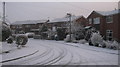
1
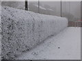
Frozen Hedgerow
This well kept hedgerow separates Nuttall Lane from the St Andrews School playing fields.
Taken on New Year's Eve 2008; the temperature that day was -5 leaving the hedgerow shrouded in a deep covering of frost.
In the distance through the freezing fog and gloom you can just make out the traffic lights on red at the junction of Bolton Road West and Nuttall Lane.
Image
Image: © Paul Anderson
Taken: 31 Dec 2008
0.01 miles
2
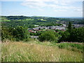
Rake Fold to Ramsbottom
Taken from Rake Fold, Holcombe, Lancashire, I am looking across Ramsbottom towards Heywood.
Image: © Carroll Pierce
Taken: 15 Jul 2015
0.04 miles
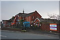
3
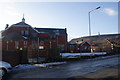
Ramsbottom Cottage Hospital
Suddenly visible after the removal of the trees which screened it. The only visibility issue now is the low winter sun. The NHS has decided it doesn't need this facility. It looks like proposals to refurbish and develop the existing building which dates from 1898 are not viable. Is demolition the only option? This option comes before the Planning Authority in April 2013.
Image: © Bill Boaden
Taken: 27 Jan 2013
0.04 miles
4
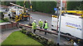
Men at Work
Engineers from BT install a new telegraph pole on Nuttall Lane in Ramsbottom.
This is the aftermath of an accident which involved a van losing control and mounting the pavement.
Not only did it severely damage the telegraph pole but also demolished the lamp post on the right that has also had to be replaced.
Image: © Paul Anderson
Taken: 3 Oct 2008
0.05 miles
5
Cleared site on Nuttall Lane
This was until recently the site of Ramsbottom Cottage Hospital. It is expected to be occupied by 13 executive homes fairly soon.
Image: © Bill Boaden
Taken: 14 Mar 2015
0.05 miles
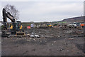
6
The demolition begins
Planning permission has been granted for about a year for the demolition of Ramsbottom Cottage Hospital. In the meantime, a new developer has acquired the land and revised plans have been approved. Finally the work is starting to go ahead.
Image: © Bill Boaden
Taken: 15 Feb 2015
0.06 miles
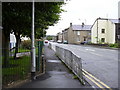
7
Nuttall Close Ramsbottom
Nuttall Close is located just off Nuttall Lane in Ramsbottom.
This photograph was taken on New Years Eve 2008 when temperatures in the area dipped to -5.
The close is made up of mainly 3 bedroom semi detached houses built in the mid 1970s.
For future reference one of these houses was on the market for £142,500 in December 2008.
Image: © Paul Anderson
Taken: 31 Dec 2008
0.06 miles
8
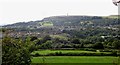
Holcombe Hill
View from Park across the Irwell Valley towards Holcombe Hill topped by the Peel Monument erected by public subscription in 1852 to celebrate Sir Robert Peel who had been responsible for the repeal of the Corn Laws and the establishment of a paid police force. The houses are built along Nuttall Lane which was once a main route to Nuttall Hall (now demolished) and Nuttall Village. They are built along a moraine left at the end of the last ice age and blocking the River Irwell which has cut a deep gorge just to the left of the picture towards Summerseat
Image: © John Tomlinson
Taken: 14 Aug 2014
0.06 miles
10

Nuttall Lane
View over Ramsbottom from Holcombe towards St. Andrew's Church, Nuttall Lane and the Irwell Gorge. The area in the photograph shows a moraine left by the last Ice Age where the River Irwell has cut a deep gorge between Ramsbottom and Summerseat.
Image: © John Tomlinson
Taken: 24 Sep 2014
0.08 miles