IMAGES TAKEN NEAR TO
Tib Street, BURY, BL0 9GX
Introduction
This page details the photographs taken nearby to Tib Street, BL0 9GX by members of the Geograph project.
The Geograph project started in 2005 with the aim of publishing, organising and preserving representative images for every square kilometre of Great Britain, Ireland and the Isle of Man.

There are currently over 7.5m images from over14,400 individuals and you can help contribute to the project by visiting https://www.geograph.org.uk
Image Map (65 Images)


Getting Data...Please wait
Leaflet Map data © OpenStreetMap
Images are licensed for reuse under creativecommons.org/licenses/by-sa/2.0
Notes
- Clicking on the map will re-center to the selected point.
- The higher the marker number, the further away the image location is from the centre of the postcode.
Image Listing (65 Images Found)
Images are licensed for reuse under creativecommons.org/licenses/by-sa/2.0
Image
Details
Distance
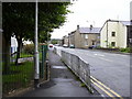
2
Wheelie Bin Lane Ramsbottom
Rear of Edgar Street on the left and the rear of Nuttall Lane on the right.
Some days you can't see this street for all the washing hung out between the houses.
Image: © Paul Anderson
Taken: 18 Jan 2007
0.04 miles
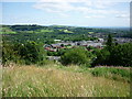
3

Nuttall Lane
View over Ramsbottom from Holcombe towards St. Andrew's Church, Nuttall Lane and the Irwell Gorge. The area in the photograph shows a moraine left by the last Ice Age where the River Irwell has cut a deep gorge between Ramsbottom and Summerseat.
Image: © John Tomlinson
Taken: 24 Sep 2014
0.05 miles
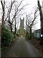
4

The tower of St Andrew's Church
As seen from the Top Field playing field.
Image: © Bill Boaden
Taken: 31 Dec 2019
0.05 miles
5
St. Andrew's, Ramsbottom
Church of England parish church currently closed and undergoing repair after damage from a lightning strike.
Image: © philandju
Taken: 12 Jan 2015
0.06 miles
6
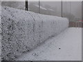
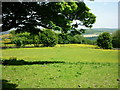
Frozen Hedgerow
This well kept hedgerow separates Nuttall Lane from the St Andrews School playing fields.
Taken on New Year's Eve 2008; the temperature that day was -5 leaving the hedgerow shrouded in a deep covering of frost.
In the distance through the freezing fog and gloom you can just make out the traffic lights on red at the junction of Bolton Road West and Nuttall Lane.
Image
Image: © Paul Anderson
Taken: 31 Dec 2008
0.06 miles
7
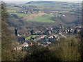
Rake Fold to Ramsbottom
Taken from Rake Fold, Holcombe, Lancashire, I am looking across Ramsbottom towards Heywood.
Image: © Carroll Pierce
Taken: 15 Jul 2015
0.07 miles
8
From One Church to Another
This picture is taken from the grounds of Image looking south east.
To the left you can see the bell tower of Image
On the hillside beyond, running from left to right under the bridge is, Image
The farm just below in front of the motorway bridge is Image
Image: © Paul Anderson
Taken: 5 Feb 2007
0.07 miles
9
Tagg Wood from Cross Lane
Taken on Cross Lane, Holcombe, Lancashire, just before the path connecting the walker to Lumb Carr Road (at the car park), I am looking east to Tagg Wood and across Ramsbottom to Harden Moor across the M66.
Image: © Carroll Pierce
Taken: 11 Jun 2015
0.07 miles
10
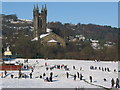
St Andrews Church Ramsbottom
With the backdrop of St Andrews Church the children from St Andrews Primary School take time out from their lessons and make the most of a recent snowfall on the schools playing fields.
Image
Image: © Paul Anderson
Taken: 3 Dec 2008
0.08 miles