IMAGES TAKEN NEAR TO
Iwerne Close, BOURNEMOUTH, BH9 3PW
Introduction
This page details the photographs taken nearby to Iwerne Close, BH9 3PW by members of the Geograph project.
The Geograph project started in 2005 with the aim of publishing, organising and preserving representative images for every square kilometre of Great Britain, Ireland and the Isle of Man.

There are currently over 7.5m images from over14,400 individuals and you can help contribute to the project by visiting https://www.geograph.org.uk
Image Map (Loading...)


Getting Data...Please wait
Leaflet Map data © OpenStreetMap
Images are licensed for reuse under creativecommons.org/licenses/by-sa/2.0
Notes
- Clicking on the map will re-center to the selected point.
- The higher the marker number, the further away the image location is from the centre of the postcode.
Image Listing (64 Images Found)
Images are licensed for reuse under creativecommons.org/licenses/by-sa/2.0
Image
Details
Distance
1
Shillingstone Drive, Muscliff, Bournemouth
Shillingstone Drive is a minor road in Muscliff, a suburb of Bournemouth. Here, the road passes a school. Mannequins either side of the road provide a reminder to drivers to slow down and keep an eye out for children.
Image: © Malc McDonald
Taken: 5 Oct 2024
0.02 miles
2
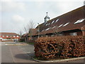
Muscliff, bungalows
Modern bungalows in Sturminster Road; local roads all seem to be named after Dorset rural towns or villages.
Image: © Mike Faherty
Taken: 1 Mar 2009
0.03 miles
3
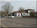
Muscliff, Tesco Express
On Shillingstone Drive; for information, seehttp://www.tesco.com/storelocator/access/details.asp?bID=5027&l=B
Image: © Mike Faherty
Taken: 1 Mar 2009
0.03 miles
4
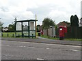
Muscliff: postbox № BH9 398, Shillingstone Drive
Shillingstone Drive is the main road through this 80s housing estate; it doesn't contain any houses itself but provides access to all the side roads. The postbox and bus shelter shown here stand opposite a convenience store, and in front of one of many grassed open spaces between the houses. The tower of the Image can be discerned through the central window of the bus shelter.
Image: © Chris Downer
Taken: 17 Aug 2008
0.04 miles
5
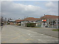
Muscliff, medical centre
Large, grand-looking medical centre in the neighbourhood centre; formally, James Fisher Medical Centre http://www.jfmc.co.uk/
Image: © Mike Faherty
Taken: 1 Mar 2009
0.06 miles
6
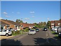
Sturminster Road, Muscliff, Bournemouth
Sturminster Road is a short residential road in Muscliff, in the northern suburbs of Bournemouth.
Image: © Malc McDonald
Taken: 5 Oct 2024
0.06 miles
7
Muscliff, Epiphany Primary School
Epiphany CE Primary School, in Shillingstone Drive. For information, see http://www.epiphany.bournemouth.sch.uk/
Image: © Mike Faherty
Taken: 1 Mar 2009
0.07 miles
8
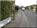
Thorncombe Close, Muscliffe, Bournemouth
Image: © Alex McGregor
Taken: 18 Oct 2010
0.09 miles
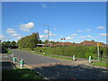
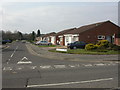
9
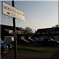
Muscliff: Moreton Road
This sign stands, unusually, not at a road junction but at the dead end of the two roads mentioned. A path runs through from here, also to Muscliffe Lane, but there is no vehicular access between the two roads here. It is only this immediate dead end of Moreton Road which falls into my 2km radius from home.
Moreton Road is on a large early-1980s estate, all of whose roads are named after Dorset villages.
The sign is the same one seen here Image It is a modern one, probably put up in the last five years or so when the borough dropped its logo from street nameplates.
This is photo no.285 of a series of 453 in my coronavirus lockdown walking project:
See Link for the complete set of photos.
Image: © Chris Downer
Taken: 12 Apr 2020
0.10 miles
10
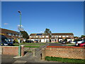
Moreton Road, Muscliff, Bournemouth
Moreton Road is a short residential road forming part of a housing development in Muscliff, on the northern outskirts of Bournemouth. Here, the housing development has been designed to enable pedestrians to pass through, but to prevent motor vehicles from using it as a short cut.
Image: © Malc McDonald
Taken: 5 Oct 2024
0.10 miles