IMAGES TAKEN NEAR TO
Cox Avenue, BOURNEMOUTH, BH9 3LY
Introduction
This page details the photographs taken nearby to Cox Avenue, BH9 3LY by members of the Geograph project.
The Geograph project started in 2005 with the aim of publishing, organising and preserving representative images for every square kilometre of Great Britain, Ireland and the Isle of Man.

There are currently over 7.5m images from over14,400 individuals and you can help contribute to the project by visiting https://www.geograph.org.uk
Image Map (Loading...)


Getting Data...Please wait
Leaflet Map data © OpenStreetMap
Images are licensed for reuse under creativecommons.org/licenses/by-sa/2.0
Notes
- Clicking on the map will re-center to the selected point.
- The higher the marker number, the further away the image location is from the centre of the postcode.
Image Listing (66 Images Found)
Images are licensed for reuse under creativecommons.org/licenses/by-sa/2.0
Image
Details
Distance
1
Muscliff: Cheddington Road
Looking northeast along this suburban road of bungalows which abound in this immediate area.
The sign is the standard Bournemouth nameplate from the 1980s, affixed with tubular steel which protrudes at each side.
This is photo no.68 of a series of 453 in my coronavirus lockdown walking project:
See https://www.geograph.org.uk/article/My-2020-Coronavirus-Lockdown-walking-project for the complete set of photos.
Image: © Chris Downer
Taken: 12 Apr 2020
0.06 miles
3
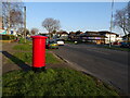
Castle Lane West (A3060)
Showing position of Postbox No. BH9 278.
Image: © JThomas
Taken: 24 Mar 2022
0.08 miles
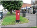
4
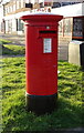
Elizabeth II postbox on Castle Lane West
Postbox No. BH9 279.
Image: © JThomas
Taken: 24 Mar 2022
0.08 miles
5
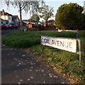
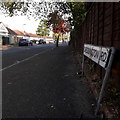
Muscliff: Cox Avenue
Cox Avenue is almost two roads: from Castle Lane West it heads roughly northeast for a while, and the driving priority of that segment morphs into the more modern Cox Close while a left turn is a continuation of Cox Avenue, northwest to Muscliffe Lane. It is a mix of houses and bungalows.
We are looking at the sign on the inside of that 90º turn, confirming the street name both ahead and to the right. The sign is the standard Bournemouth nameplate from the 1980s, affixed with tubular steel which protrudes at each side.
This is photo no.92 of a series of 453 in my coronavirus lockdown walking project:
See https://www.geograph.org.uk/article/My-2020-Coronavirus-Lockdown-walking-project for the complete set of photos.
Image: © Chris Downer
Taken: 12 Apr 2020
0.09 miles
6

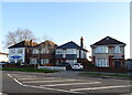
Muscliff: a gym banner on Castle Lane
Looking along the usually busy Castle Lane West at about 11 o'clock in the evening, past a banner for a boxing gym which occupies one of the premises on this parade.
Image: © Chris Downer
Taken: 11 Jan 2017
0.09 miles
7
Muscliff: postbox № BH9 278, Castle Lane West
This postbox used to be a few hundred yards southwest of here, outside Priory View Road Post Office. However, a while after that closed in 2004, the shop it was within followed suit and was demolished to make way for flats, while the postbox was moved to its present position.
Image: © Chris Downer
Taken: 18 Jul 2008
0.10 miles
8
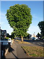
Muscliff: horse chestnut in Castle Lane West
A large tree, one of numerous of various species, along Castle Lane West along the northern suburbs of Bournemouth. The little parade of shops in the distance, right, includes a fish and chip shop and is on the corner of Redbreast Road North.
Image: © Chris Downer
Taken: 26 Jul 2013
0.11 miles
9
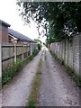
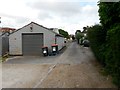
Moordown: Priory View Place heads east
Priory View Place is essentially a rear access lane to shops on Castle Lane West, between Priory View Road and Redbreast Road North, but it does have a couple of residential properties along it. It also forms public footpath M12.
Here, we look eastward from a short way in from the Redbreast end.
See Image for the next view along the lane ahead, and Image for the next view behind us, each with links to further views along the route.
Image: © Chris Downer
Taken: 10 Jul 2016
0.11 miles
10
Moordown: Priory View Place goes from gravel to tarmac
Priory View Place is essentially a rear access lane to shops on Castle Lane West, between Priory View Road and Redbreast Road North, but it does have a couple of residential properties along it. It also forms public footpath M12.
Here, we are about halfway along, where the surface changes from gravel to tarmac.
See Image for the next view along the lane ahead, and Image for the next view behind us, each with links to further views along the route.
Image: © Chris Downer
Taken: 10 Jul 2016
0.11 miles