IMAGES TAKEN NEAR TO
Castle Lane West, BOURNEMOUTH, BH9 3LA
Introduction
This page details the photographs taken nearby to Castle Lane West, BH9 3LA by members of the Geograph project.
The Geograph project started in 2005 with the aim of publishing, organising and preserving representative images for every square kilometre of Great Britain, Ireland and the Isle of Man.

There are currently over 7.5m images from over14,400 individuals and you can help contribute to the project by visiting https://www.geograph.org.uk
Image Map
Images are licensed for reuse under creativecommons.org/licenses/by-sa/2.0
Notes
- Clicking on the map will re-center to the selected point.
- The higher the marker number, the further away the image location is from the centre of the postcode.
Image Listing (64 Images Found)
Images are licensed for reuse under creativecommons.org/licenses/by-sa/2.0
Image
Details
Distance
1
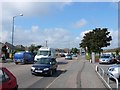
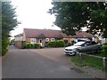
The A3060 near Throop, Bournemouth
Looking west from Broadway roundabout
Image: © Nigel Mykura
Taken: 13 Sep 2008
0.02 miles
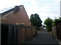
2
Charminster: Luckham Gardens from Luckham Road
This small modern infill, around the back of houses on Luckham Road, uses the start of public footpath M16 as its access. The footpath can be seen as it continues southward in the distance.
See Image for a view of the houses in Luckham Gardens, and links to further photos along the footpath.
Image: © Chris Downer
Taken: 11 Jul 2016
0.05 miles
3
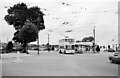
Castle Lane West at Charminster road ? 1966
The wide open space of the junction has since been filled with a large roundabout.
Bournemouth Corporation trolleybus 282 is turning into Charminster Road on its way to Bournemouth Square on service 29. It is one of the Sunbeam MF2B type, with Weymann bodywork with which Bournemouth virtually renewed its trolleybus fleet in the late 1950s and early 1960s. Despite this investment, a change in policy resulted in the system closing in 1969.
This is one of a series of views featuring buses in the 60s, 70s, and 80s. http://www.geograph.org.uk/search.php?i=2114547&displayclass=slide
Image: © Alan Murray-Rust
Taken: 30 Aug 1966
0.05 miles
4
Charminster: Luckham Gardens and footpath M16
This small infill of a few modern houses is a recent afterthought, before which the public footpath, which we see to the left, would have continued to Luckham Road, just behind us, with much the same appearance.
See Image for the view towards us from ahead, with further links to photos along the route, and Image for the view from behind us on Luckham Road.
Image: © Chris Downer
Taken: 11 Jul 2016
0.06 miles
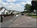
5
Charminster: bungalow frontages on Castle Lane
A close-up of some of the frontages of Image, each very similar but slightly different, at about 8 o'clock on a summer evening. The shadow of the aerial of the first high gable can be seen cast on the next bungalow along.
Image: © Chris Downer
Taken: 26 Jul 2013
0.06 miles
6
Charminster: footpath M16 arrives on Luckham Gardens
This public footpath nears its northern end, passing a small infill of a few modern houses. They are a recent afterthought, before which the path would have continued as a simple path to Luckham Road, which we see in the distance.
See Image for the view towards us from ahead, and Image for the next view behind us, with further links to photos along the route.
Image: © Chris Downer
Taken: 11 Jul 2016
0.06 miles
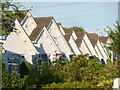
7
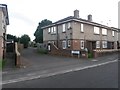
Muscliff: bungalows in Castle Lane
This distinctive line of bungalows, at 189-203 Castle Lane West catches the sun this fine lunchtime. Castle Lane West and East form the A3060, a busy road across Bournemouth's northern suburbs, and these bungalows benefit from having a service road between them and the main carriageway.
Image: © Chris Downer
Taken: 22 Jun 2008
0.07 miles
9
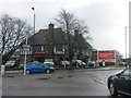
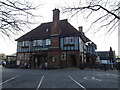
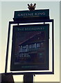
Charminster: the Broadway pub
This pub stands on the busy junction of Castle Lane (ahead/behind), Charminster Road (to right), and Broadway Lane (left), from which latter street it takes its name. The pub has had a bit of a rough reputation in the past but this has improved markedly during the last couple of landlords' tenancies and it is a good local with good food and good atmosphere.
Image: © Chris Downer
Taken: 5 Mar 2017
0.08 miles