IMAGES TAKEN NEAR TO
Greenwood Road, BOURNEMOUTH, BH9 2LH
Introduction
This page details the photographs taken nearby to Greenwood Road, BH9 2LH by members of the Geograph project.
The Geograph project started in 2005 with the aim of publishing, organising and preserving representative images for every square kilometre of Great Britain, Ireland and the Isle of Man.

There are currently over 7.5m images from over14,400 individuals and you can help contribute to the project by visiting https://www.geograph.org.uk
Image Map
Images are licensed for reuse under creativecommons.org/licenses/by-sa/2.0
Notes
- Clicking on the map will re-center to the selected point.
- The higher the marker number, the further away the image location is from the centre of the postcode.
Image Listing (109 Images Found)
Images are licensed for reuse under creativecommons.org/licenses/by-sa/2.0
Image
Details
Distance
1
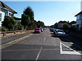
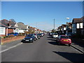
Bournemouth : Winton - Greenwood Road
This photo was taken from Namu Road and shows a residential area.
Image: © Lewis Clarke
Taken: 8 Mar 2010
0.03 miles
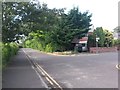
2
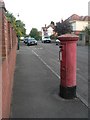
Winton: postbox № BH9 325, Greenwood Road
Looking south along Greenwood Road past this George V-reign postbox which hasn't seen a paintbrush in a while.
Image: © Chris Downer
Taken: 25 Jun 2008
0.05 miles
3
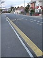
STOP, but no BUS
It appears that the painters have omitted a word; in any case, buses no longer come along Bengal Road so it no longer matters.
Image: © Chris Downer
Taken: 14 Apr 2008
0.07 miles
4
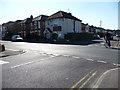
Bournemouth : Winton - Namu Road & Bengal Road Junction
A road junction which takes you from Namu Road, and left of the road is Bengal Avenue, right is Victoria Avenue.
Image: © Lewis Clarke
Taken: 8 Mar 2010
0.08 miles
5
Bournemouth : Winton - Namu Road
Namu Road looking back towards Winton. The road has no vehicle access here to Boundary Road which is just behind the photographer.
Image: © Lewis Clarke
Taken: 8 Mar 2010
0.08 miles
6
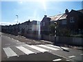
Bournemouth : Zebra Crossing on Victoria Avenue
A crossing on Victoria Avenue to help pedestrians safely cross.
Image: © Lewis Clarke
Taken: 4 Oct 2007
0.08 miles
7
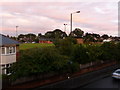
Winton: Victoria Park
Looking down from the Boundary Road footbridge towards this football ground, among housing in the west of Winton. The car in the foreground is travelling along the A347 Boundary Road, towards the town centre.
Image: © Chris Downer
Taken: 29 Jul 2009
0.09 miles
8
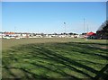
Bournemouth : Victoria Park
Victoria Park is home of the Bournemouth Football Club. Before the Poppies moved here this was just a farmer's field.
Image: © Lewis Clarke
Taken: 8 Mar 2010
0.10 miles
9
Winton: bridleway N03 passes Namu Road
When Namu Road, and the other parallel roads along here, were built, this would have been a dead end with a gravel or dirt track leading ahead and behind us, forming Boundary Road. Today, however, there is a tarmacked road linking each side road with the next, although it is intermittent.
The route is still, though, a public bridleway, incorporating the tarmacked sections and the paths in between. See Image for more discussion on the history of Boundary Road.
Meanwhile, see Image for the next view along the bridleway ahead, and Image for the next one behind us: each provides further links to photos along the route.
Image: © Chris Downer
Taken: 8 Jul 2016
0.10 miles
10
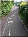
Winton: cyclists and pedestrians swap sides on bridleway N03
This looks like a peculiar arrangement, and possibly unnecessary. But part of the idea, I'm sure, is that it provides a cycling link from the main Boundary Road, which is just over the hedge on the right, with the carriageway ahead. This of course wouldn't be possible without cyclists switching sides.
See Image for more discussion on the route and history of the bridleway.
See Image for the view towards us from a short distance ahead, and Image for the next view behind us, each giving links to further pictures along the route.
Image: © Chris Downer
Taken: 8 Jul 2016
0.10 miles