IMAGES TAKEN NEAR TO
Coronation Avenue, BOURNEMOUTH, BH9 1TR
Introduction
This page details the photographs taken nearby to Coronation Avenue, BH9 1TR by members of the Geograph project.
The Geograph project started in 2005 with the aim of publishing, organising and preserving representative images for every square kilometre of Great Britain, Ireland and the Isle of Man.

There are currently over 7.5m images from over14,400 individuals and you can help contribute to the project by visiting https://www.geograph.org.uk
Image Map
Images are licensed for reuse under creativecommons.org/licenses/by-sa/2.0
Notes
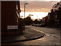
- Clicking on the map will re-center to the selected point.
- The higher the marker number, the further away the image location is from the centre of the postcode.
Image Listing (88 Images Found)
Images are licensed for reuse under creativecommons.org/licenses/by-sa/2.0
Image
Details
Distance
1
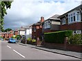
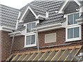
Endfield Road, Bournemouth
This is the view south of these 1930's houses in Endfield Rd close to the junction with Coronation Avenue.
Image: © Nigel Mykura
Taken: 28 Aug 2009
0.02 miles
2
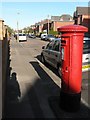
Moordown: postbox № BH9 134, Limited Road
Looking along Limited Road, a small residential street, from its western end.
This George V-reign postbox is my local one. Returning home from a fortnight's holiday a couple of years ago, I came here to post a letter only to find a square of tarmac where the postbox had stood – I am pleased to report it was reinstated a few months later.
Image: © Chris Downer
Taken: 3 Jul 2008
0.06 miles
3
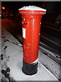
Moordown: snow-capped postbox
Image does not often have this appearance; it followed Bournemouth's heaviest snowfall for some years, occurring overnight and today. The picture was taken at about 10 o'clock in the evening.
Image: © Chris Downer
Taken: 2 Feb 2009
0.06 miles
4
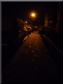
Moordown: footprints in the snow in Garth Road
Snowy footprints on the approach to a lamppost on this short residential street.
Image: © Chris Downer
Taken: 2 Feb 2009
0.07 miles
5
As contemporary as you can get
This dwelling in Muscliffe Road, Moordown, is just nearing completion and has been adorned with a date stone for 2007 – the first one I have seen.
Image: © Chris Downer
Taken: 15 Jul 2007
0.09 miles
7
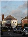
Winton: chimneypot shadows
Looking along the northern segment of Benmore Road towards a house in Brassey Road whose roof is hosting an interesting shadow of a nearby chimney.
Image: © Chris Downer
Taken: 23 Nov 2008
0.12 miles
8
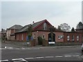
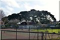
Moordown: Church of the Nazarene
A small church on the corner of Mayfield Road (ahead and behind) and Queen Mary Avenue (left and right). The 1975 Kelly's Directory lists it as the Andrew Vine Memorial Church of the Nazarene, but I can find no mention of Andrew Vine today.
Image: © Chris Downer
Taken: 24 Feb 2008
0.12 miles
9
Winton: Castle Road
Looking along the western half of Castle Road from the Muscliffe Road crossroads. After an overcast and drizzly day, the sun finally decided to make an appearance at about 8pm, from under the immediate cloud cover.
Image: © Chris Downer
Taken: 29 Jul 2009
0.13 miles
10
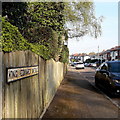
Moordown: King Edward Avenue
One of three consecutive monarchical avenues in Moordown, King George and Queen Mary Avenues being parallel to the south. They comprise typical Moordown housing - decent detached houses from the reign of Edward and the Georges in the 20th century.
The sign is an old cast-iron one from the 1950s, not exactly a rarity but nice to see surviving, refixed to a more modern fence.
This is photo no.221 of a series of 453 in my coronavirus lockdown walking project:
See https://www.geograph.org.uk/article/My-2020-Coronavirus-Lockdown-walking-project for the complete set of photos.
Image: © Chris Downer
Taken: 12 Apr 2020
0.14 miles