IMAGES TAKEN NEAR TO
Pine Road, BOURNEMOUTH, BH9 1LY
Introduction
This page details the photographs taken nearby to Pine Road, BH9 1LY by members of the Geograph project.
The Geograph project started in 2005 with the aim of publishing, organising and preserving representative images for every square kilometre of Great Britain, Ireland and the Isle of Man.

There are currently over 7.5m images from over14,400 individuals and you can help contribute to the project by visiting https://www.geograph.org.uk
Image Map
Images are licensed for reuse under creativecommons.org/licenses/by-sa/2.0
Notes
- Clicking on the map will re-center to the selected point.
- The higher the marker number, the further away the image location is from the centre of the postcode.
Image Listing (50 Images Found)
Images are licensed for reuse under creativecommons.org/licenses/by-sa/2.0
Image
Details
Distance
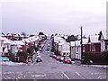
1
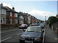
Charminster, Green Road
Mixed Edwardian/1920s housing in Green Road.
Image: © Mike Faherty
Taken: 28 Mar 2009
0.07 miles
2
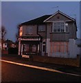
Charminster: former Gresham Road Post Office
At dusk, from this angle, the whitewashed remains of the words "Gresham" and "Office" can just be discerned on the white panel above the door, catching the light of the lamppost opposite.
The building is at 44 Charminster Avenue, on the corner of Gresham Road which gave the post office its name, and it is now an estate agent.
The post office replaced an earlier branch named Strouden Road in 1926, and closed down on 6 March 2004.
Image: © Chris Downer
Taken: 3 Mar 2008
0.11 miles
3
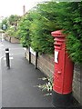
Winton: postbox № BH9 195, Frampton Road
This George V-reign postbox serves typical Bournemouth suburbia, and is in Frampton Road close to its junction with Green Road (left to right) and Murley Road (seen in the distance).
Image: © Chris Downer
Taken: 12 Jul 2008
0.11 miles
4
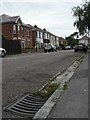
Winton: aging kerbstones in Murley Road
This is one of the very few roads to still have these primitive kerbstones and gutters. We moved into our house nearby in 1987 and ours were updated fairly soon after.
Image: © Chris Downer
Taken: 12 Jul 2008
0.11 miles
5
Winton: snowy rooftops
Looking down Murley Road, which turns into Frampton Road in the bottom of the dip, with white rooftops all around.
Two days after heavy snow earlier in the week had all thawed, this fresh lot fell from the north this morning, despite the fact that the day started rainy, with large puddles all around.
By nightfall, the main carriageways of all roads were clear of snow and ice, so this was a very heavy fall considering that it started and had almost disappeared on the same day.
Image: © Chris Downer
Taken: 6 Feb 2009
0.11 miles
6
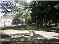
Charminster, Fampoux Gardens
Linear gardens between Firbank & Green Roads http://www.bournemouth.gov.uk/Library/PDF/Landscape/DRAFT%20WOODLAND%20STRATEGY%2006-2006.pdf Commemorates the death of soldiers from the Hampshire Regiment at the defence of Fampoux in 1918 http://www.wintonforum.co.uk/wintongreatwar.html
Image: © Mike Faherty
Taken: 28 Mar 2009
0.11 miles
7

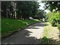
Turf Zone "FampouxGarden"
Small Park off Green Road.
Image: © Ian S
Taken: 15 Nov 2022
0.13 miles
8
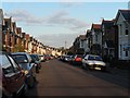
Charminster: Acland Road
Acland Road is typical of the side streets on this stretch of Charminster: seemingly endless lines of gables curving into the distance, built in the 1920s, before the need for parking was foreseen.
Image: © Chris Downer
Taken: 14 Apr 2008
0.14 miles
9
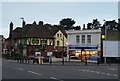
Charminster: nameless fish & chip shop
This corner premises was a Spar grocery store until the late 1990s, and was taken over by this fish & chip shop after a couple of years of emptiness. It appears bereft of an actual name, but it is open, as you can see, on a Sunday evening.
The Fiveways pub is next door.
Image: © Chris Downer
Taken: 2 Mar 2008
0.15 miles
10
Charminster: Fampoux Gardens
These small gardens abut the eastern end of Green Road and adjoin Firbank Road. At the top end is a small memorial stone (Image) which says simply, "These gardens, laid out by ex servicemen, are named to commemorate the gallant stand of the Hampshires at Fampoux." The workmen's cabins visible at the far end are here during the council's resurfacing of Firbank and Green Roads.
For much more discussion on this small garden, see the Winton Forum page here: http://www.wintonforum.co.uk/fampoux.html
Image: © Chris Downer
Taken: 22 Jun 2008
0.15 miles