IMAGES TAKEN NEAR TO
Mallard Close, BOURNEMOUTH, BH8 9PG
Introduction
This page details the photographs taken nearby to Mallard Close, BH8 9PG by members of the Geograph project.
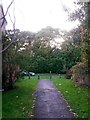
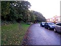
The Geograph project started in 2005 with the aim of publishing, organising and preserving representative images for every square kilometre of Great Britain, Ireland and the Isle of Man.

There are currently over 7.5m images from over14,400 individuals and you can help contribute to the project by visiting https://www.geograph.org.uk
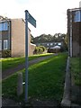
Image Map
Images are licensed for reuse under creativecommons.org/licenses/by-sa/2.0
Notes
- Clicking on the map will re-center to the selected point.
- The higher the marker number, the further away the image location is from the centre of the postcode.
Image Listing (84 Images Found)
Images are licensed for reuse under creativecommons.org/licenses/by-sa/2.0
Image
Details
Distance
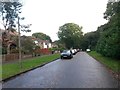
1
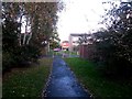
Strouden: footpath K08 reaches Mallard Close
Looking along this public footpath as it heads from Seagull Road to Mallard Close. Here, it arrives at the latter and, technically, crosses Mallard Close to join path K05 which runs alongside the road on the grass.
See:
Image for the view down the path from ahead;
Image for the next view behind us; and
Image for the view along that stretch of footpath K05.
Image: © Chris Downer
Taken: 16 Oct 2016
0.01 miles
2
Strouden: footpath K08 from Mallard Close
Looking along this public footpath as it heads from Mallard Close to Seagull Road. Technically, it seems from relevant maps that the public right of way crosses the road to reach our feet, where footpath K05 runs alongside the road on the grass.
See Image for the next view on path K08 ahead, and Image for a view along this stretch of Mallard Road and further discussion on path K05.
These links contain further links to photos along each route.
Image: © Chris Downer
Taken: 16 Oct 2016
0.01 miles
3
Strouden: footpath K08 crosses a rear driveway
Looking along this public footpath as it heads for Seagull Road from Mallard Close. Here, it crosses a rear access driveway which runs between the two roads.
See Image for the next view on the path ahead, and Image for the next view behind us.
Image: © Chris Downer
Taken: 16 Oct 2016
0.01 miles
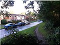
4
Strouden: Mallard Close and the grassy start of footpath K05
Looking along this short dead-end road at the back of a smallish council housing estate. Also, a public right of way, public footpath K05, starts here and heads straight along the grass ahead, diverging from Mallard Close further along to head to East Way.
Meanwhile, the paved path on our left heads into Strouden public open space, perfectly usable but not a designated public right of way.
See Image for the next view along Mallard Close ahead, with links to further photos on the course of the public footpath.
Image: © Chris Downer
Taken: 16 Oct 2016
0.02 miles
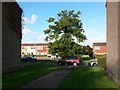
5
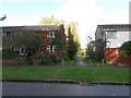
Strouden: Mallard Close
Looking along this short dead-end road at the back of a smallish council housing estate. Also, a public right of way, public footpath K05, heads along the grass on the right towards us and leads through woods to East Way behind us.
See:
Image for the view along here from the end of the public right of way ahead;
Image for the next view behind us on path K05; and
Image for a view along footpath K08, which heads left by the black car.
The latter two have links to further photos along each route.
Image: © Chris Downer
Taken: 16 Oct 2016
0.02 miles
6
Strouden: footpath K08 from Seagull Road
Looking along this public footpath from Seagull Road as it heads for Mallard Close.
See Image for the view towards us from just ahead, with links to further photos on the path.
Some maps show the public right of way continuing behind us - there is still a path but it is not now designated as such. The above linked photo shows the path we are talking about and gives further details.
Image: © Chris Downer
Taken: 16 Oct 2016
0.02 miles
7
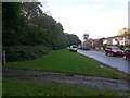
Strouden: footpath K08 arrives on Seagull Road
Looking along this public footpath as it arrives on Seagull Road from Mallard Close. It does so at an elongated roundabout which serves no vehicular purpose (there are no turnings) but has a fine, large tree in its centre. (There is second one too: Image)
Some maps show the public right of way continuing along the similar paved path beyond, onto the Mallard Road open space; however, that part is no longer designated as such. The same tree is in the centre of the following picture - Image - which is on another footpath on the open space.
See Image for the view towards us from the road ahead, and Image for the next view on the path behind us.
Image: © Chris Downer
Taken: 16 Oct 2016
0.03 miles
8
Strouden: footpath K05 joins Mallard Close
This public footpath comes from East Way, through lightly wooded area on its way to Mallard Close. Here, we see it as it reaches Mallard Close; the mapped course of the public right of way appears to then follow the grass alongside the road.
See Image for the next view on the path behind us, and Image for the next view ahead - each with links to further pictures along the route.
Image: © Chris Downer
Taken: 16 Oct 2016
0.04 miles
9
Strouden: footpath K05 veers off from Mallard Close
This public footpath comes from East Way, through lightly wooded area on its way to Mallard Close. Here, we see it emerging onto Mallard Close before the course of the public right of way follows the grass alongside the road.
See Image for the view onto the road from just up the path ahead, and Image for the next view behind - each with links to further pictures along the route.
Image: © Chris Downer
Taken: 16 Oct 2016
0.04 miles
10
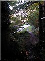
Strouden: footpath K05 drops down to Mallard Close
This public footpath comes from East Way, through lightly wooded area on its way to Mallard Close. Here, we see it descending onto Mallard Close before the course of the public right of way follows the grass alongside.
See Image for the next view on the path behind us, and Image for the next view ahead - each with links to further pictures along the route.
Image: © Chris Downer
Taken: 16 Oct 2016
0.04 miles