IMAGES TAKEN NEAR TO
Inglewood Avenue, BOURNEMOUTH, BH8 9JZ
Introduction
This page details the photographs taken nearby to Inglewood Avenue, BH8 9JZ by members of the Geograph project.
The Geograph project started in 2005 with the aim of publishing, organising and preserving representative images for every square kilometre of Great Britain, Ireland and the Isle of Man.

There are currently over 7.5m images from over14,400 individuals and you can help contribute to the project by visiting https://www.geograph.org.uk
Image Map (Loading...)


Getting Data...Please wait
Leaflet Map data © OpenStreetMap
Images are licensed for reuse under creativecommons.org/licenses/by-sa/2.0
Notes
- Clicking on the map will re-center to the selected point.
- The higher the marker number, the further away the image location is from the centre of the postcode.
Image Listing (41 Images Found)
Images are licensed for reuse under creativecommons.org/licenses/by-sa/2.0
Image
Details
Distance
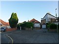
1
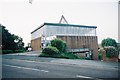
Strouden: parish church of St. Barnabas
An unusual, modern, squareish building which, from the other side, looks quite striking as one is looking uphill towards it (see Image).
Image: © Chris Downer
Taken: 7 Jun 2007
0.09 miles
2

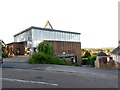
Queen's Park, St Barnabas
Built 1968, in a commanding position at the top of Mount Pleasant Drive; part of the United Benefice of Holdenhurst & Iford. http://www.unitedbenefice.co.uk/unitben/wrshp/ub_services.php#stbarn
Image: © Mike Faherty
Taken: 3 Mar 2009
0.09 miles
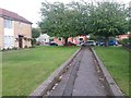
3
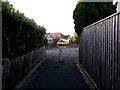
Strouden: footpath K34 approaches Craigmoor Close
This public footpath leads from Leydene Close to the similar dead end of Craigmoor Close, ahead.
See Image for the view towards us from the turning area, and Image for the next view on the path behind us, with links to further photos on both mentioned routes.
Image: © Chris Downer
Taken: 13 Jul 2016
0.10 miles
4
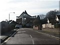
Strouden: Craigmoor Close and St. Barnabas
Looking along this quiet residential cul-de-sac, with the impressive Image, whose entrance is on Mount Pleasant Drive, around the other side and on considerably higher ground.
Image: © Chris Downer
Taken: 12 Jan 2008
0.10 miles
5
Strouden: St. Barnabas? church and access to footpath K50
A similar view of Image, but taken from a subtly different angle to give us the view down the steep car park. At the bottom corner of the car park, we can just see the stone pillar at the start of a short public footpath. It is only 14m in length and leads to another footpath, K34, for access to Craigmoor Close or Leydene Close.
The church is built on steeply sloping ground (see Image for a view from down Craigmoor Close, the road behind the church).
See Image for a view along the path from its start - including links to further photos along both continuing routes.
Image: © Chris Downer
Taken: 13 Jul 2016
0.10 miles
6
Strouden: footpath K34 from Craigmoor Close
This public footpath heads diagonally from the dead end of Craigmoor Close, heading for the similar dead end in Leydene Close.
Behind the bungalows we see the back of Image, to which an offshoot path also connects from midway along. The church is built on steeply sloping ground and the main access from Mount Pleasant Drive is at a higher level. (See Image for a view from down the road behind us.)
See Image for the view towards us from along the path, and further links to photos towards Leydene Close and the church.
Image: © Chris Downer
Taken: 13 Jul 2016
0.10 miles
7
Strouden: footpath K32 approaches Vanguard Road
The opposite view to Image on this public footpath from Craigmoor Avenue. The houses on the left are the highest even numbers of Craigmoor Avenue, even though its dead end is about 150 yards behind us.
A similar path runs alongside the odd numbers and also comes out at the dead end of Craigmoor Avenue: Image
See Image for the next view behind us on this path.
Image: © Chris Downer
Taken: 25 Jun 2016
0.10 miles
8
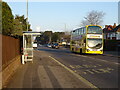
Bus stop and shelter on Castle Lane West (A3060)
Image: © JThomas
Taken: 24 Mar 2022
0.11 miles
9
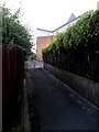
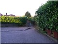
Strouden: footpath K50 to St. Barnabas? church
This public footpath ranks among the shortest dozen in Bournemouth, measuring 14 metres in length. Here, we see all of it, from footpath K34 to the back of the church car park (Image). Though the extent of the official right of way ceases there, there is unhindered access to Mount Pleasant Drive ahead.
The church is built on steeply sloping ground and the main access from Mount Pleasant Drive ahead is at a higher level. (See Image for a view from down Craigmoor Close, behind us.)
See:
Image for a view along the path from ahead;
Image for a wider view of the church and down to the path; and
Image for a view of the path junction at which we are standing.
Image: © Chris Downer
Taken: 13 Jul 2016
0.11 miles
10
Strouden: footpath K50 from St. Barnabas? church car park
This public footpath ranks among the shortest dozen in Bournemouth, measuring 14 metres in length. Here, we see all of it, from the back of the church car park (Image). Though the extent of the official right of way ceases there, there is unhindered access to Mount Pleasant Drive behind us - see Image
At the lamppost, one reaches footpath K34 and can turn left for Craigmoor Close or right for Leydene Close.
See Image for a view along the path from the far end, with links to further photos along path K34.
Image: © Chris Downer
Taken: 13 Jul 2016
0.11 miles