IMAGES TAKEN NEAR TO
Queens Park Avenue, BOURNEMOUTH, BH8 9EY
Introduction
This page details the photographs taken nearby to Queens Park Avenue, BH8 9EY by members of the Geograph project.
The Geograph project started in 2005 with the aim of publishing, organising and preserving representative images for every square kilometre of Great Britain, Ireland and the Isle of Man.

There are currently over 7.5m images from over14,400 individuals and you can help contribute to the project by visiting https://www.geograph.org.uk
Image Map (Loading...)


Getting Data...Please wait
Leaflet Map data © OpenStreetMap
Images are licensed for reuse under creativecommons.org/licenses/by-sa/2.0
Notes
- Clicking on the map will re-center to the selected point.
- The higher the marker number, the further away the image location is from the centre of the postcode.
Image Listing (35 Images Found)
Images are licensed for reuse under creativecommons.org/licenses/by-sa/2.0
Image
Details
Distance
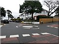
1
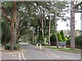
Queen's Park Avenue, Bournemouth
Queen's Park Avenue is a tree-lined road in the suburbs of Bournemouth.
Image: © Malc McDonald
Taken: 7 Feb 2022
0.09 miles
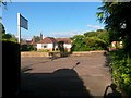
2
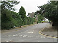
Howard Road, Queen's Park, Bournemouth
Howard Road is a residential road in the Queen's Park area of Bournemouth.
Image: © Malc McDonald
Taken: 7 Feb 2022
0.10 miles
3
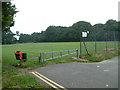
Queens Park, Bournemouth
This is the west end car park area of Queens Park.
Image: © Stuart Buchan
Taken: 1 Aug 2005
0.10 miles
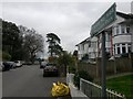
4
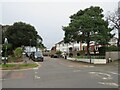
Howard Road, Queen's Park, Bournemouth
Howard Road is a residential road in Queen's Park, a suburb of Bournemouth.
This section, at the northernmost end of the road, is a cul-de-sac which leads to a recreation ground.
Image: © Malc McDonald
Taken: 7 Feb 2022
0.14 miles
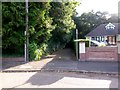
5
Queen?s Park: mini-roundabout on Howard Road
Looking up the final stretch of Howard Road, a short stub of road that gives access to Strouden Open Space. This segment is designated as a byway open to all traffic (or B.O.A.T.) and had a gravel surface before being tarmacked perhaps 10 or 15 years ago.
The route heading left-to-right is the more major one in terms of traffic, and this junction marks the point at which Strouden Avenue (left) becomes Brackendale Road.
See Image for the next view along the byway ahead.
Image: © Chris Downer
Taken: 25 Feb 2017
0.15 miles
6
Charminster: footpath K03 reaches Burnham Drive
This public footpath from Howard Road emerges onto Burnham Drive at its top end. The road in each direction here goes round in a circle before dropping down to Queen's Park Avenue, so this is effectively a dead end, with the bungalow in front of us one of those on the inside of the circle.
See Image for a view towards us from across the road, and Image for the view behind us, and links to further photos along the path.
Image: © Chris Downer
Taken: 13 Jul 2016
0.15 miles
7
Queen?s Park: the sign for byway K44
Looking up the final stretch of Howard Road, a short stub of road that gives access to Strouden Open Space. It is designated as a byway open to all traffic (or B.O.A.T.), number K44 as the sign tells us, and had a gravel surface before being tarmacked perhaps 10 or 15 years ago.
See Image for a wider view from behind us, and Image for the view towards us from the top of the road ahead.
Image: © Chris Downer
Taken: 25 Feb 2017
0.15 miles
8
Charminster: footpath K03 from Burnham Drive
This broad path heads for Howard Road from the top end of Burnham Drive, through a very secluded route among trees.
See Image for the view towards us as the path arrives here, and links to further photos along the route.
Image: © Chris Downer
Taken: 13 Jul 2016
0.15 miles
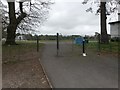
9
Queen?s Park: a van does a U-turn on byway K44
Looking down the final stretch of Howard Road, a short stub of road that gives access to Strouden Open Space (from which we are looking). It is designated as a byway open to all traffic (or B.O.A.T.), and had a gravel surface before being tarmacked perhaps 10 or 15 years ago.
See Image for the view towards us from the bottom of the byway, and Image for the view this way through the gate onto the recreation ground.
Image: © Chris Downer
Taken: 25 Feb 2017
0.15 miles
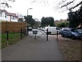
10
Queen?s Park: byway K44 reaches Strouden Open Space
The final stretch of Howard Road is designated as a byway open to all traffic (or B.O.A.T.), and leads from Strouden Avenue to the recreation ground just in front of us - the gate therefore marks the end of the public right of way, although a footpath continues along the left-hand edge of the public open space to Mallard Road.
See Image for a view behind us down Howard Road.
Image: © Chris Downer
Taken: 25 Feb 2017
0.16 miles