IMAGES TAKEN NEAR TO
Wellington Road, BOURNEMOUTH, BH8 8JD
Introduction
This page details the photographs taken nearby to Wellington Road, BH8 8JD by members of the Geograph project.
The Geograph project started in 2005 with the aim of publishing, organising and preserving representative images for every square kilometre of Great Britain, Ireland and the Isle of Man.

There are currently over 7.5m images from over14,400 individuals and you can help contribute to the project by visiting https://www.geograph.org.uk
Image Map (Loading...)


Getting Data...Please wait
Leaflet Map data © OpenStreetMap
Images are licensed for reuse under creativecommons.org/licenses/by-sa/2.0
Notes
- Clicking on the map will re-center to the selected point.
- The higher the marker number, the further away the image location is from the centre of the postcode.
Image Listing (304 Images Found)
Images are licensed for reuse under creativecommons.org/licenses/by-sa/2.0
Image
Details
Distance
2
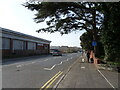
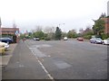
Bournemouth : Wellington Road
Wellington Road in Bournemouth goes under the Wessex Way
Image: © Lewis Clarke
Taken: 6 Feb 2009
0.04 miles
3
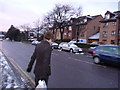
Bournemouth: former bus stop in Wellington Road
The yellow pole used to host a Bus Stop sign, for this is the former route of the 17, a service which went from Alum Chine to Throop, taking a tortuous route through the suburbs. It became the 18 in the evenings and on Sundays, which took a slightly different route further north from here.
When the Yellow Buses underwent a renumbering in July 2007, the 17 became the 24 and at the same time some of the kinks were taken out of its route, meaning that this bus stop became redundant. The bench remains, though.
Image: © Chris Downer
Taken: 26 Mar 2009
0.04 miles
4
Bournemouth : Holdenhurst Road, behind Halfords & Staples
A road leading to the railway station's car park and the rear of Halfords and Staples.
Image: © Lewis Clarke
Taken: 6 Feb 2009
0.05 miles
5
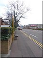
Springbourne: Portchester Place
When the town-centre by-pass was put through in the 1970s (the green road sign is visible to the left), several of these parallel roads were severed, as can be seen from the map. The 'Road' endings were retained on the western side, while Place and Close and Gardens were substituted for these small sections on the east. This is Portchester Place, while Portchester Road is on the other side; likewise for example Lowther Gardens and Lowther Road, Shelbourne Close and Shelbourne Road, etc.
This particular road also happens to mark where Ascham Road would originally have come out on Portchester Road – it can be seen from the map that Ascham Road would have continued roughly north and would have been a relatively major route (running into Bennett Road which is coloured yellow on the map). This explains why the right-hand arm as we look has a large street-light while a typical smaller side-road lamppost is seen on the left.
Image: © Chris Downer
Taken: 26 Mar 2009
0.05 miles
6
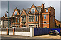
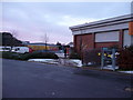
Bournemouth: former Drill Hall, 177 Holdenhurst Road
Former Headquarters and Drill Hall of the 5th/7th Battalion Hampshire Regiment (Territorial Force Depot), at 177 Holdenhurst Road.
Image: © Mike Searle
Taken: 10 May 2014
0.05 miles
7
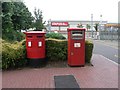
Bournemouth: postbox №s BH8 400 and 400B, Wellington Road
These postboxes have Bournemouth's latest final collection time on weekdays, 7:30p.m., because it is outside the Image The two apertures of the left-hand box, № 400, have no distinction - both are for stamped mail – while franked mail should be put in the squareish box to the right, № 400B.
Image: © Chris Downer
Taken: 10 Jul 2008
0.05 miles
8
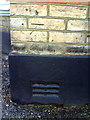
Benchmark on Portchester Health Centre Dental Practice
Ordnance Survey cut mark benchmark described on the Bench Mark Database at http://www.bench-marks.org.uk/bm36375
Image: © Roger Templeman
Taken: 21 Dec 2010
0.05 miles
9
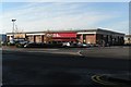
Bournemouth: Parkway Retail Park
Quite a salubrious name for a complex comprising two stores! On the corner of the station approach, this site was once occupied by Furnitureland, a store that burnt down about 20 years ago, and part of the old sorting office, which was demolished and replaced alongside about 10 years ago. The roundabout in the picture is the junction of Holdenhurst and Wellington Roads.
Image: © Chris Downer
Taken: 21 Nov 2007
0.05 miles
10
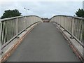
Springbourne: glimpse of rooftops
A view of the rooftops of Springbourne from a footbridge crossing the main road. The footbridge is public footpath C21.
See:
Image for a view of the path as it ascends the eastern spiral ramp;
Image for a view of the spiral path as it reaches ground level on the western side; and
Image for a view of the western spiral from outwith the bridge.
Image for a view of the
Image: © Chris Downer
Taken: 10 Jul 2008
0.06 miles