IMAGES TAKEN NEAR TO
Holdenhurst Road, BOURNEMOUTH, BH8 8DA
Introduction
This page details the photographs taken nearby to Holdenhurst Road, BH8 8DA by members of the Geograph project.
The Geograph project started in 2005 with the aim of publishing, organising and preserving representative images for every square kilometre of Great Britain, Ireland and the Isle of Man.

There are currently over 7.5m images from over14,400 individuals and you can help contribute to the project by visiting https://www.geograph.org.uk
Image Map
Images are licensed for reuse under creativecommons.org/licenses/by-sa/2.0
Notes
- Clicking on the map will re-center to the selected point.
- The higher the marker number, the further away the image location is from the centre of the postcode.
Image Listing (122 Images Found)
Images are licensed for reuse under creativecommons.org/licenses/by-sa/2.0
Image
Details
Distance
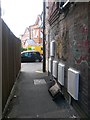
1

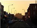
Gables on Holdenhurst Road
Some turn of the 1900s style.
Image: © Neil Owen
Taken: 7 Sep 2021
0.02 miles
2
Springbourne: Holdenhurst Road
Looking southwest down Holdenhurst Road, the view ends with the McCarthy & Stone offices (see Image).
Image: © Chris Downer
Taken: 28 Dec 2008
0.02 miles
3
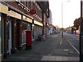
Springbourne: Malmesbury Park Post Office and postbox № BH8 41
Since 1973 when the main dual carriageway was built, it has provided a natural boundary between what would be considered Springbourne and Malmesbury Park, although there never was an official boundary. It thus now seems odd that the post office is called Malmesbury Park, when most of that area is not terribly accessible from here.
Image: © Chris Downer
Taken: 28 Dec 2008
0.02 miles
4
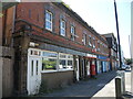
Post Office on Holdenhurst Road
Alongside the office are some rather older shop frontages. The dark, glazed tiles and features suggest a more opulent past (perhaps a pub or chemists); sadly the last occupant, a European food shop, moved out some time ago and the weeds moved in.
Image: © Neil Owen
Taken: 22 Jun 2022
0.02 miles
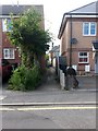
5
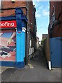
Springbourne: footpath D05 to Stanley Road
Looking along this narrow footpath leading from Holdenhurst Road.
See Image for the view out of the path towards us.
Image: © Chris Downer
Taken: 1 Jul 2016
0.03 miles
6
Springbourne: footpath D05 emerges onto Holdenhurst Road
This narrow public footpath arrives on the main Holdenhurst Road. See Image] for the view up the path towards us, and Image for a view from the other end behind us.
Image: © Chris Downer
Taken: 1 Jul 2016
0.03 miles
7
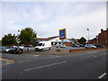
Springbourne, Aldi
Supermarket on Holdenhurst Road.
Image: © Mike Faherty
Taken: 12 Sep 2012
0.04 miles
8

Roofline on Holdenhurst Road
A pairing of windows and weeds.
Image: © Neil Owen
Taken: 7 Sep 2021
0.04 miles
9
Springbourne: footpath D05 to Holdenhurst Road
A narrow public footpath leads from Stanley Road to the main Holdenhurst Road - see Image for a view as it reaches the far end.
Image: © Chris Downer
Taken: 1 Jul 2016
0.04 miles
10
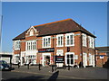
Pints of beer, pints of milk
The former Dolphin Hotel on Holdenurst Road is now a Tesco store. Once a Whitbread property, it later changed hands to Greene King until the early twenty-first century.
Image: © Neil Owen
Taken: 22 Jun 2022
0.04 miles