IMAGES TAKEN NEAR TO
Bramshaw Gardens, BOURNEMOUTH, BH8 0BS
Introduction
This page details the photographs taken nearby to Bramshaw Gardens, BH8 0BS by members of the Geograph project.
The Geograph project started in 2005 with the aim of publishing, organising and preserving representative images for every square kilometre of Great Britain, Ireland and the Isle of Man.

There are currently over 7.5m images from over14,400 individuals and you can help contribute to the project by visiting https://www.geograph.org.uk
Image Map
Images are licensed for reuse under creativecommons.org/licenses/by-sa/2.0
Notes
- Clicking on the map will re-center to the selected point.
- The higher the marker number, the further away the image location is from the centre of the postcode.
Image Listing (53 Images Found)
Images are licensed for reuse under creativecommons.org/licenses/by-sa/2.0
Image
Details
Distance
1
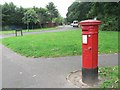
Throop: postbox № BH8 70, Chesildene Drive
This Victorian postbox certainly hasn't been in this position since it was manufactured! This is a 1980s housing estate, before which this area was just farmland.
Image: © Chris Downer
Taken: 18 Jul 2008
0.09 miles
2
Strouden: Yeomans Road roundabout
Yeomans Road is one of the main routes to the vast 1980s Muscliff housing estate, and here it reaches a roundabout with the estate to the left. An industrial estate is to the right, behind the Castlepoint shopping centre.
Meanwhile, Yeomans Road continues ahead as a gravel road, and a public right of way - a byway open to all traffic (or B.O.A.T.) number K21 - leading to Throop Road.
See Image for the view along the gravel road from the other side of the roundabout, and links to further photos on the route.
Image: © Chris Downer
Taken: 20 Jul 2016
0.11 miles
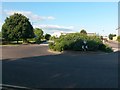
3
Strouden: start of the gravel section of Yeomans Road
Yeomans Road is one of the original tracks in the Throop area. Today, the southern segment is one of the main roads onto the modern housing estate, but its northern section is still a gravel road. The gravel section forms a public right of way - a byway open to all traffic (or B.O.A.T.) number K21 - and this is the view as it enters suburbia at its southern end.
The opening onto the roundabout here is slightly at odds with the straight course of Yeomans Road on both sides of it - the distant lamppost far-left demonstrates the tarmac continuation of the road.
The bus is heading round the roundabout to the Yeomans Way industrial estate, where the town's bus depot is situated.
See Image for the view towards us, and Image for the next view along Yeomans Road behind us - and links to further photos along the route.
Image: © Chris Downer
Taken: 20 Jul 2016
0.12 miles
4
Strouden: Yeomans Road heads for Throop
Yeomans Road is one of the original tracks in the Throop area. Today, the southern segment is one of the main roads onto the modern housing estate, but its northern section is still a gravel road. The gravel section forms a public right of way - a byway open to all traffic (or B.O.A.T.) number K21 - and this is the view from the fringe of the modern development.
To the right is the back of the Castlepoint shopping centre, with Yeomans Way leading to an industrial estate behind it.
See Image for a wider view across the roundabout just to our right, and Image for the view towards us from along the gravel road - and links to further photos along the route.
Image: © Chris Downer
Taken: 20 Jul 2016
0.12 miles
5
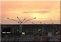
Strouden: the sun disappears above Boot?s
The sun disappears behind a low cloud for the last time of the day, behind Boot’s the Chemists in Castlepoint shopping centre.
Image: © Chris Downer
Taken: 7 Aug 2007
0.13 miles
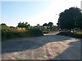
6
Throop: passing 19 Yeomans Road
Yeomans Road is one of the original tracks in the Throop area. Today, the southern segment is one of the main roads onto the modern housing estate, but its northern section is still a gravel road. The gravel section forms a public right of way - a byway open to all traffic (or B.O.A.T.) number K21 - and this is the view north as it enters the properly rural parts and reaches the first of several properties on either side.
See Image for the next view on the road ahead, and Image for the next view behind us - each with links to further photos along the route.
Image: © Chris Downer
Taken: 20 Jul 2016
0.14 miles
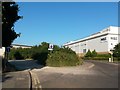
7

Strouden: playing field alongside Yeomans Road
Yeomans Road is one of the original tracks in the Throop area. Today, the southern segment is one of the main roads onto the modern housing estate, but its northern section is still a gravel road. The gravel section forms a public right of way - a byway open to all traffic (or B.O.A.T.) number K21.
Here, a playing field abuts the eastern edge of the housing estate alongside Yeomans Road as it heads north.
See Image for the next view on the road ahead, and Image for the next view behind us - each with links to further photos along the route.
Image: © Chris Downer
Taken: 20 Jul 2016
0.14 miles
8

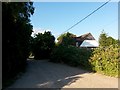
Muscliff: Mill Road (North) from Cadnam Way
Looking along Mill Road (North), which forms byway open to all traffic (or B.O.A.T.) number K22, from its southern end. It is a historical route pre-dating the modern 1980s housing estate here, and it used to extend along Mill Road (South) behind us, before the latter segment was incorporated into the modern housing estate as part of the public highway. The route can still be eminently followed on its dead-straight course behind us, although the estate roads curve across the route.
See Image for the next view along the road ahead, with links to further pictures along the route.
Image: © Chris Downer
Taken: 16 Jul 2016
0.15 miles
9
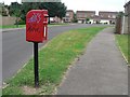
Throop: postbox № BH8 176, Landford Way
While roads in the similar 80s housing estate to the west of Broadway Lane are named after Dorset villages, this estate's roads are named after west Hampshire villages – this is Landford Way and in the distance is the junction with Tytherley Green (named after West and East Tytherley).
Image: © Chris Downer
Taken: 18 Jul 2008
0.16 miles
10
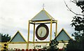
Strouden: Hampshire Centre clock
The Hampshire Centre was opened in 1968 and was thus a very early example of an out-of-town shopping centre. This clock was installed towards the latter end of the centre's life. It was closed and demolished in the late 1990s and in its place was built Image
Image: © Chris Downer
Taken: Unknown
0.16 miles