IMAGES TAKEN NEAR TO
Regent Drive, BOURNEMOUTH, BH7 7RW
Introduction
This page details the photographs taken nearby to Regent Drive, BH7 7RW by members of the Geograph project.
The Geograph project started in 2005 with the aim of publishing, organising and preserving representative images for every square kilometre of Great Britain, Ireland and the Isle of Man.

There are currently over 7.5m images from over14,400 individuals and you can help contribute to the project by visiting https://www.geograph.org.uk
Image Map
Images are licensed for reuse under creativecommons.org/licenses/by-sa/2.0
Notes
- Clicking on the map will re-center to the selected point.
- The higher the marker number, the further away the image location is from the centre of the postcode.
Image Listing (51 Images Found)
Images are licensed for reuse under creativecommons.org/licenses/by-sa/2.0
Image
Details
Distance
1
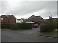
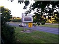
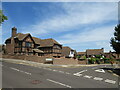
Bournemouth, Littledown Surgery
Littledown is a mainly residential suburb of western Bournemouth. Anyone interested in the health of the area's residents need look no further than this surgery's "QOF" (Quality & Outcomes Framework);
http://www.gpcontract.co.uk/surgery.php?orgcode=J81067
Image: © Mike Faherty
Taken: 12 Dec 2008
0.08 miles
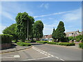
2
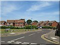
Walsingham Dene, Littledown, Bournemouth
Walsingham Dene forms part of a modern housing development in Littledown, in the north-eastern suburbs of Bournemouth.
Image: © Malc McDonald
Taken: 21 Jun 2022
0.09 miles
3
Springbank Road, Littledown, Bournemouth
Springbank Road forms part of a modern housing development in Littledown, in the north-eastern suburbs of Bournemouth.
Image: © Malc McDonald
Taken: 21 Jun 2022
0.11 miles
4
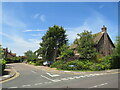
Littledown: postbox № BH7 84, Harewood Crescent
A modern postbox on this small, recent housing estate – dating from the late 1980s – of which Harewood Crescent is the main thoroughfare.
Image: © Chris Downer
Taken: 13 Jul 2008
0.12 miles
6
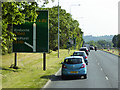
Queen?s Park: Think! Don?t drink and drive
Looking along the main A338 Wessex Way from the foot/cycle path that runs alongside it.
Road safety messages are displayed when there are no traffic hold-ups to report, such a reminder to wear seatbelts, to keep a special eye out for motorcycles, or as here - not to drink and drive.
Image: © Chris Downer
Taken: 13 Jul 2016
0.15 miles
7
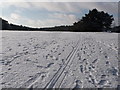
Queen?s Park: seventh fairway under snow
Looking along the seventh fairway, right in the northeast corner of the golf course. Where golfers would normally tread, these footprints belong to those who have come to enjoy the park by sledge!
Image: © Chris Downer
Taken: 18 Dec 2010
0.15 miles
8
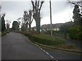
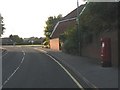
Bournemouth Harewood Road, bungalows
Littledown became available for housing development in the 1930s; this stretch of Harewood Road is lined with bungalows. Note the pollarded trees.
Image: © Mike Faherty
Taken: 12 Dec 2008
0.16 miles
9
Elmgate Drive, Littledown, Bournemouth
Elmgate Drive forms part of a modern housing development in Littledown, in the north-eastern suburbs of Bournemouth.
Image: © Malc McDonald
Taken: 21 Jun 2022
0.16 miles
10
Harewood Avenue, Littledown, Bournemouth
Harewood Avenue is a residential road in Littledown, in the north-eastern suburbs of Bournemouth.
Image: © Malc McDonald
Taken: 21 Jun 2022
0.16 miles