IMAGES TAKEN NEAR TO
Petersfield Road, BOURNEMOUTH, BH7 6QE
Introduction
This page details the photographs taken nearby to Petersfield Road, BH7 6QE by members of the Geograph project.
The Geograph project started in 2005 with the aim of publishing, organising and preserving representative images for every square kilometre of Great Britain, Ireland and the Isle of Man.

There are currently over 7.5m images from over14,400 individuals and you can help contribute to the project by visiting https://www.geograph.org.uk
Image Map
Images are licensed for reuse under creativecommons.org/licenses/by-sa/2.0
Notes
- Clicking on the map will re-center to the selected point.
- The higher the marker number, the further away the image location is from the centre of the postcode.
Image Listing (66 Images Found)
Images are licensed for reuse under creativecommons.org/licenses/by-sa/2.0
Image
Details
Distance
1
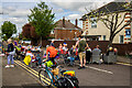
Coronation 2023 - Petersfield Road Street Party
-
Image
Image: © Mike Searle
Taken: 7 May 2023
0.04 miles
2
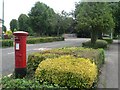
Boscombe East: postbox № BH7 228, Harewood Avenue
This postbox is between the turnings with Meon and Durrington Roads in an area with several such roads named after Hampshire villages.
Image: © Chris Downer
Taken: 19 Jul 2008
0.09 miles
3
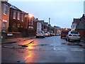
Pokesdown: Leaphill Road on leap day
The only road in the Bournemouth/Poole area with the word 'Leap' in its name, pictured on the leap day of 2008.
Image: © Chris Downer
Taken: 29 Feb 2008
0.11 miles
4
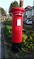
George V postbox on Harewood Avenue
Postbox No. BH7 228.
Image: © JThomas
Taken: 23 Mar 2022
0.11 miles
5
Pokesdown: footpath J06 from Leaphill Road
This public footpath is one of four rear accesses to premises in Clarence Park Road - two on this odds side and two on the evens side. We see it here from its northern end, along Leaphill Road.
See Image for the next photo on the path ahead, with links to further photos along the route.
Image: © Chris Downer
Taken: 25 Feb 2017
0.13 miles
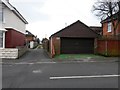
6
Pokesdown: footpath J06 and Leaphill Mews
This public footpath is one of four rear accesses to premises in Clarence Park Road - two on this odds side and two on the evens side.
The row of houses here, accessed from it, are called Leaphill Mews and are recently built in the former back garden of 1 Leaphill Road, which is just alongside us.
See Image for the view along the path from the end behind us, and Image for the next photo on the path ahead, with links to further photos along the route.
Image: © Chris Downer
Taken: 25 Feb 2017
0.13 miles
7
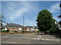
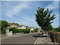
Swanmore Road, Bournemouth
Swanmore Road is a residential road in the suburbs of Bournemouth.
Image: © Malc McDonald
Taken: 21 Jun 2022
0.13 miles
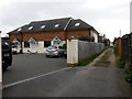
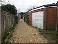
8
Pokesdown: footpath J05 from Rebbeck Road
This public footpath is one of four rear accesses to premises in Clarence Park Road - two on this evens side and two on the odds side.
See Image for the next view on the path, with links to further photos along the route.
Image: © Chris Downer
Taken: 25 Feb 2017
0.14 miles
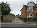
9
Petersfield Road, Bournemouth
Petersfield Road is a residential road in the north-eastern suburbs of Bournemouth.
Image: © Malc McDonald
Taken: 21 Jun 2022
0.14 miles
10
Pokesdown: footpath J05 heads for Rebbeck Road
This public footpath is one of four rear accesses to premises in Clarence Park Road - two on this evens side and two on the odds side.
See Image for the next view on the path ahead, and Image for the next view behind us - each with links to further photos along the route.
Image: © Chris Downer
Taken: 25 Feb 2017
0.14 miles