IMAGES TAKEN NEAR TO
Harewood Avenue, BOURNEMOUTH, BH7 6NB
Introduction
This page details the photographs taken nearby to Harewood Avenue, BH7 6NB by members of the Geograph project.
The Geograph project started in 2005 with the aim of publishing, organising and preserving representative images for every square kilometre of Great Britain, Ireland and the Isle of Man.

There are currently over 7.5m images from over14,400 individuals and you can help contribute to the project by visiting https://www.geograph.org.uk
Image Map (Loading...)


Getting Data...Please wait
Leaflet Map data © OpenStreetMap
Images are licensed for reuse under creativecommons.org/licenses/by-sa/2.0
Notes
- Clicking on the map will re-center to the selected point.
- The higher the marker number, the further away the image location is from the centre of the postcode.
Image Listing (26 Images Found)
Images are licensed for reuse under creativecommons.org/licenses/by-sa/2.0
Image
Details
Distance
1
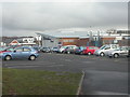
Bournemouth, Avonbourne School
In the southern half of this square, OS shows 4 adjacent schools. Westernmost is Avonbourne, a girls' secondary.
http://www.avonbourne.org/folders/avonbourne_school/
Image: © Mike Faherty
Taken: 12 Dec 2008
0.05 miles

4
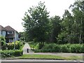
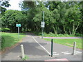
Footpath and cycle route near Littledown, Bournemouth
A path for walking and cycling, leading towards King's Park in the north-eastern suburbs of Bournemouth.
Image: © Malc McDonald
Taken: 21 Jun 2022
0.09 miles
5
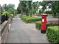
Boscombe East: postbox № BH7 290, Harewood Avenue
The middle one of three George V-reign postboxes in Harewood Avenue.
Image: © Chris Downer
Taken: 19 Jul 2008
0.09 miles
6

George V postbox on Harewood Avenue
Postbox No. BH7 290.
Image: © JThomas
Taken: 23 Mar 2022
0.09 miles
7
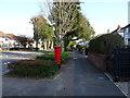
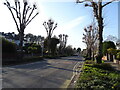
Harewood Avenue
Showing position of Postbox No. BH7 290.
Image: © JThomas
Taken: 23 Mar 2022
0.10 miles
8

Bournemouth, Portchester School
In the southern part of this square, OS shows a band of 4 schools. Second from the west is Portchester School, a boys' secondary.
http://www.portchester.bournemouth.sch.uk/
Image: © Mike Faherty
Taken: 12 Dec 2008
0.10 miles
9
Footpath and cycle route, Littledown, Bournemouth
A shared path for walking and cycling in Littledown, in Bournemouth's north-eastern suburbs.
Image: © Malc McDonald
Taken: 21 Jun 2022
0.14 miles
10
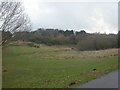
Littledown Common
Small area of common, once much larger, between housing development & schools. Grassland, scrub, deciduous trees, and conifers on the ridge. Note the "bumps" in an informal bike circuit in the middle ground.
http://www.bournemouth.gov.uk/Library/PDF/Landscape/DRAFT%20WOODLAND%20STRATEGY%2006-2006.pdf
Image: © Mike Faherty
Taken: 12 Dec 2008
0.14 miles